Car navigation PROGOROD is not only maps and routing around the world, not depending on the availability of the Internet, but also the ability to save on gasoline, car maintenance and services, as well as on some categories of goods. Install PROGOROD and, thanks to our partners, you will receive discounts on fuel, auto parts, tire fitting, evacuation and much more.
More than a million drivers are already using the PROGOROD car navigator!
Traffic jams and speed cameras will no longer take you by surprise. Difficult junctions are clear and simple with our realistic intersection images.
You don't need the Internet to use PROGOROD navigation! You will only need to connect if you use the traffic jam service, but here we have also minimized the use of traffic.
You can download navigation and use all the functionality for free for 10 days, and upon registration - another 20!
Maps of Russia and more than 60 countries of the world are always available for you FREE OF CHARGE directly in the application. You can view a list of available world maps from the OpenStreetMap project on our website or directly in the application.
If you do not have space on your device, you can use online maps of Russia, but we recommend downloading maps of your region to be able to use navigation in any conditions.
The map of Russia is updated daily!
The main functions of PROGOROD:
- Using maps without the Internet.
- Three route options with the ability to set intermediate points.
- Voice input and the system keyboard.
- Indication of lanes on the road
- Dynamic map adjustments.
- Alerts for speed cameras, speed bumps, pedestrian crossings and more.
- Screen "Antiradar" shows maneuvers along the route and warns of cameras, speed bumps, dangerous intersections, etc.
- "HUD" (Head-Up Display) - screen for projection on windshield cars important information along the route.
- 3D map display mode with houses close to reality.
- Search for addresses, gas stations, shops, cafes and other objects.
- Program control using gestures.
- Service Geoblogs will warn you about the dangers on the road.
- Taking into account the traffic situation (traffic jams) when building routes.
- End-to-end routing between countries.
- Profitable partnership programs.
- Free call directly from the program in VOSEP (All-Russian operational service emergency assistance victims of an accident).
User support: [email protected]
Join the PROGOROD user community:
Facebook http://www.facebook.com/pages/PROGOROD/241633452526114
VKontakte http://vk.com/club24014731
Operators mobile communication may charge a fee according to your tariff plan, for the use of data transmission when using the "CORK" service.
Licensed via in-app purchase, Family Sharing is not supported.
Frequently asked Questions:
1. There is no voice dialing.
To activate voice search you must enable the system iOS keyboard in the National Assembly "PROGOROD". To do this, you must disable the option "Settings-System settings-Other settings-Built-in keyboard".
2. Doesn't catch satellites.
For the program to work correctly with satellites, check that the iOS settings the "Geolocation" function is enabled (Settings-Confidentiality-Services-Geolocation) and the use of geolocation is allowed for the PROGOROD program.
3. License.
Under standard conditions Apple Store:
- you can purchase a license only through the Apple Store;
- license transfer between iOS and any other platforms is not possible;
- one license can be assigned to 5 devices by one Apple id account.
4. Routing between countries and regions.
To plot a route between maps of different states / regions, go to the "Maps" section of the program and make active maps of the required countries / regions using the "+" button. After activation, click the “Apply” button (a circle with a check mark). The program will reboot and start working with several cards at the same time.
I am a fairly active user of devices on android base, and the news about the release of a navigator based on this operating system, Prestigio GeoVision GV5500AND, which, by the way, became the millionth sold navigator of the brand, served as an informational reason for this review. This navigator works with the Progorod navigation program, which served as a starting point for me in this review. I decided to look for a navigation program that is more functional than the pre-installed service from Google, which would be convenient to use both on the tablet and on the phone.
Actually, today we will not talk about him (not about Prestigio GeoVision GV5500AND), but about navigation program "Progorod", which has versions for most popular mobile OS - it is installed on satellite navigators under windows management CE, has versions for iOS and Bada, and for Android, of course. (There is also a version for Windows Mobile, however, new devices on this OS have not been released for a long time.)
I have tested the program on ZTE V9 + tablet and LG P350 phone.
The screenshots for the article were made with the help of the latter, since it was quite easy to ruin it, in contrast to the tablet.
So the installation:
Installation is possible via Google Play Marketand from installation file, which can be downloaded from the program website.
Full installation instructions are on the same page, and it is detailed in the User's Guide. After installing the program, it's better to connect to wi-Fi networks, since after launching it will offer to download maps of the desired region, I immediately downloaded a package of maps for the whole of Russia about 512 MB in size - the other day my wife and I are going to go on vacation to St. Petersburg. And then - a lot is not a little, maybe it will come in handy. You can also download maps in archive from the site before starting the program and put them on a memory card. On iOS, you will have to download maps, apparently only through the program.

The purchase of a license on iOS devices is made only through the AppStore, on Android we download the program for free, then we buy a license on the website, and we are given an activation key and a file that must be put on the memory card in the program folder.

Form for obtaining a license.
Here I acted as a beta tester for another not obvious moment: I initially installed the program on a tablet and registered it on this device. It seemed logical to me, since and it works better with GPS than my LG P350, and its screen is larger, but then it suddenly turned out that I had unnecessarily updated to the latest firmware, therefore, I could not get root rights on it and make screenshots for the article. However, this moment, it turns out, is provided in the "Progorod". Across personal Area in a special form, it is enough to write a request to the support service with the name of the device on which the program is installed and indicate the reason for the license transfer. I indicated that the current device is faulty (the absence of root is a fault in our case, right ?! ;-)), and prepared to wait, a day or two, knowing from experience how such services are usually loaded. My surprise knew no bounds when, after a maximum of 30 minutes, I received a notification in my mail that the license was transferred and I can register it on a new device. Five points to the support team, you are great!

This is how a letter about re-registering a license for another device looks like.
We installed the program, maps, now we can run the program. At the first launch, we agree with the use of the "plug" service in beta mode (for Russia), otherwise it will not work, which is logical. In Ukraine, this service has not yet been implemented, but there is information that a joint car navigation product MAPS.UA, travelGPS and Progorod will be launched soon, which will lead to more accurate and up-to-date maps of Ukraine and, probably, support for online services.
So, before us is the main menu.
It turned out that Progorod for Android and iOS supports OpenGL and can display 3D maps, which is quite convenient. I liked the ability to twist, tilt and scale the map with multitouch gestures, in addition, the three-dimensional terrain scheme looks like the real world. However, in the settings, all these bells and whistles can be disabled in order to increase performance.

The main menu of the program.

The main menu of the program is quite intuitive, with a mass useful functions even inexperienced users can hardly get lost in them.
The item "On the map" will move directly to the map and allow you to quickly orient yourself on the ground.
"Search" works quite well, there is a POI search, search by address, by coordinates. The history and our "Favorites" are also stored here.

Quick menu available on the map screen.
“Route” allows you to view information about the current route, maneuvers, detours, build a return route and save the trip log file. 
"Settings" are redundant, see the screenshot for yourself. 

Map view settings.
The item "Personal", it duplicates information from "Search" on route history and favorites, here we can also get access to the log and "my warnings". 
“Augmented reality” is an interesting function, you can see what POIs are nearby with the camera turned on, pointing at the road. Something stopped updating normally. "Street view on google maps", So I will definitely use this feature. 
Navigation:
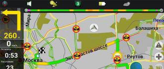
The main menu displays a map (you can choose two-dimensional or three-dimensional modes, day and night, or automatic), several control buttons (menu, quick menu with access to your most popular items, zoom, traffic light and compass, clicking on which will expand the map to north) and various indicators: speed, level of satellite signal reception, time, etc.

City map view

Poi setup

Route planning options


The program has two quite pleasant voices (male and female) commenting on the situation on the route, in addition, the Junction View function pleases - a photorealistic image of a complex junction that appears when you approach it. This feature will help those new to driving or in unfamiliar terrain.

Junction View

About the program.
My conclusion is that the program is convenient and easy to learn, it is functional - it allows you to consider all the necessary interchanges, 3D models of buildings, taking into account the number of storeys, if you have an Internet connection, there are also "traffic jams" (though not everywhere yet). The support service works promptly, in case of problems it helps quickly, which is also a definite plus. In general, I liked the program, I will use it. You can make your own opinion by downloading the 30-day trial version.
Automotive navigation ProGorod is a multifunctional navigation system that allows you to search for objects and build a route to them, displays travel information using up-to-date maps of all of Russia, 707 cities and towns with detailed "home".
With the help of the Menaco software package, it is possible to install ProGorod into the standard head unit of the car.
The ProGorod system (demo version) is installed in the extended and maximum configurations of Menaco.
Main functions of ProGorod
- The program is designed for platforms Windows CE, iOS, Android, Win Mobile.
- The program works in offline navigation mode. Internet access is not required for ProGorod operation).
- Intelligent mode of voice guidance IQ Voice GuideTM informs the driver of navigation data while driving along the route, is able to inform the driver in advance about approaching a video camera or a dangerous section of the route.
- The ProCity Traffic function is online service... With the help of Menaco Internet (extended and maximum configuration of Menaco), the multimedia recorder can be connected to the Internet to use the "online traffic" function.
- The system allows you to download OpenStreetMaps maps.
- The Antiradar function (SpeedCam) warns of approaching speed cameras, speed bumps, etc.
- The HUD function provides the ability to project information from the device monitor onto the car's windshield. If the program is installed on the vehicle's SHGU, this function is not required.
- IN latest version the program added the service of calling the All-Russian operational emergency service in case of an accident in case of an accident.
Important
- Please note when ordering that navigation charts ProGorod is not included in the configuration of Menaco. When placing an order, put the cards you want in the basket.
- As part of the Menaco firmware, ProGorod navigation is delivered in a demo version. Demo version of ProGorod means that the trial version of the program is installed. You can use this version for 30 days from the date of the first launch in order to test this navigation system. If during acquaintance you have decided to continue using the program, then you need to buy a ProGorod license. More details here https://www.pro-gorod.ru/support/faq.
- Progorod maps (junction and / or maps folders) are located on a USB flash drive (or on an SD card) in the Progorod \\ folder
- The demo period expires in 30 days. If the program does not start in demo mode, as a recommendation, you can try to delete the progorod.bin file in the progorod folder on the flash drive (memory card).
Documentation ProGorod
ProGorod User Guide: http://www.pro-gorod.ru/documents/Manual.pdf
Authorization: http://www.pro-gorod.ru/auth/
Activation (video): https://youtu.be/YnRzjobgnf0
Navigator Progorod saves time on the road, choosing the best path, and helps to adhere to the rules through voice prompts. Car navigation is rapidly evolving, and it takes a lot of work to meet customer needs. But Progorod surprises with a huge set of functions and ease of use.
So that drivers can use the Progorod on different devices, several versions of the program were created for different operating systems... It is supported on the following platforms:
- Android;
- Samsung BADA;
- Windows Mobile;
- navigators with operating windows system CE.
The city works with data obtained using GPS and GLONASS navigation systems.

Almost all maps of the world can be downloaded from the official website:
- Russia;
- Ukraine;
- Poland;
- Czech Republic;
- all countries of Europe and the USA.
The city does not just lay out routes, it has many useful functions that will be useful to the driver:
- Traffic jams. The route can be changed along the way to avoid traffic jams
- Dynamic edits. The markings or speed limits change every day on different roads. The developers analyze this information and add relevant information to the application every day.
- Geoblogs. Each user of this program can add some useful information. For example, about repairing a road or some kind of accident.
- Traffic lanes. Warns the driver about a maneuver in advance so that he can change to the desired lane. The application tells you which lane is better to drive not only before a maneuver, but also on different sections of the road.
- 3D buildings. This feature allows you to see all the buildings nearby in 3D, which allows users to better navigate the area. All buildings and structures will be presented on a scale.
- Day and night mode. The color scheme of the map will change depending on the time of day.
- Voice prompts. Throughout the route, Progorod will notify the driver of maneuvers voice prompts... This feature can always be disabled in the settings.
In addition to various functions, do not forget about its direct purpose - routing. The user can compose any path with any number of stops.

Important! Some features require an internet connection.
Reviews of owners of navigators with software Progorod
Although Progorod is not yet as popular as other navigation systems, it already has its fans. Here are some reviews from those who have already tried the app.
Irina, 38 years old.
I used several applications, but the ones that worked for me were in English. Unfortunately, I don't understand English, so I started looking for alternative applications. As a result, I found the Progorod. I would like to say a huge thank you to the developers, because this is exactly what I was looking for.
Nikolay, 35 years old.
I stumbled upon the Progorod navigator by chance and decided to try it out, just a trip to the region was planned. The route was short and convenient, at the end I arrived exactly at the right address. The program warned about traffic jams, it helped not to get stuck on the road. Now I always use Progorod.
Constantine, 43 years old.
City - good program for navigation and more. Once I went with him for a week, it works great and provides a lot of information, for example, about traffic jams or road repairs. As a result, I switched to a simpler application, but I would definitely recommend Progorod to others.
Navigator ProGorod is a fairly old development that has its own circle of users, but is still not very well known. But in vain. The program is quite good, has many pluses (as well as minuses, of course, even the leaders of the sphere are not spared from them). With the peculiarities of its use, as well as with such an important point as updating maps, we will introduce you in this material.
A bit of history
Navigator City (or rather - navigation system) appeared almost 10 years ago, in 2009. It came out with a whole scattering of applications, and most importantly - with its own maps, in which the creators laid quite a few exclusive ideas of their own production. In 2011, the second basic version of the application (2.0) was released, which is still being modified. At the moment, version 2.0.3336 is offered for download on the official website.
What features does the Progorod navigator have?
The city has versions for all more or less known operating systems: Android, iOS, Samsung Bada, Win Mobile, Win SE. Uses cards own development, and these maps cover the territory of all of Russia, Ukraine, Belarus, Moldova, Kazakhstan, all of Europe and the United States.
Like most professional apps, Progorod is a paid product with a free 30-day trial period. If you download the navigator to Android through the Playmarket, then you can use it for 10 days absolutely free, and the next 20 days - only if you register. At the end of this period, you will have to decide whether you like it and whether you will buy it. The cost on the Playmarket is 900 rubles. Having paid once for the application, you will receive further software and map updates absolutely free of charge, and also have the opportunity to use various services, which are described below.
The first feature that many users will like: the Progorod navigator can be used without the Internet. And not just conditionally, but fully. The Internet is only needed to use the "Traffic" service, but the traffic there is so small that it can be almost ignored.
60 minutes of driving on Moscow streets will consume only 1 MB of traffic.
When planning a trip to a certain point, you have the opportunity to get 3 route options at once, and on each of them you can set your own points.
Dynamic map updates are made daily.
The Progorod navigator has a very advanced 3D mode. Perhaps one of the best among all navigation developments. By switching to it, you get almost 100% transmission of the landscape with the real height of buildings, objects and their relative position.
When driving on a multi-lane road, you get an exact indication of which lane to move in. It is highlighted in red. Now you have not just an instruction to "turn right", but you see a specific lane along which you need to move.
 Data entry and control of the program is possible by voice, gesture and keyboard.
A full cycle of information and warnings about road events: cameras, speed bumps, pedestrian crossings, intersections that require increased attention and much more. Your Progorod becomes the center where all information about the situation on your route is collected.
A separate service is informing about traffic jams with building a detour route. Moreover, among all Russian-language navigation software, this is the most sparing traffic jam service in terms of traffic consumption.
Universal and advanced search: you can search by addresses, types of objects (gas stations, shops, etc.), coordinates.
 Convenience when traveling abroad. Navigator Progorod can use free maps OSM (OpenStreetMap). Thus, for orientation on the roads abroad, you only need your smartphone with the Progorod program and pre-downloaded OSM-maps of the region where you are going. The map data is downloaded from the MapStore service in the interface of the program itself.
Various bonuses and affiliate programs for owners.
Working with the program
The program works in vertical, horizontal, day and night modes. The card is very sensitive to touch; you can twist and move it with two fingers. On the road, the driver has access to everything desired buttons and functions: zoom in / out the map, change the angle, add points of interest menu, charge indicators, enable traffic jams.
The menu itself is built logically, and there are many settings in it. The user has the ability to customize the Progorod navigator subtly to suit his needs, and these are not empty words. You can change everything up to the font size on the map.
The main disadvantage of searching is that there is no universal mode. But all other modes work very correctly (address, sightseeing, etc.). It is possible to search by intersections and by the placed cursor on the map. By the way, in the second case, it is very convenient to receive information about an object on the map - just put the cursor on it, mark the place, and it will appear extra menu with information about the object and about interesting places around it.
As we have already briefly said above, the user has the ability to build / get 3 routes at once between the selected points. Navigator Progorod offers the shortest route, the fastest taking into account traffic jams and just spent time, as well as the most convenient. By convenience, the creators understand the path along major streets, autobahns, i.e. with the least number of turns, intersections, etc.
Each route has its own internal settings: set detour options, exclude non-asphalt roads. While on the road, you get all the necessary upcoming information: how fast you can move on this section, where cameras and other data are hanging.
Nice additions
 An exclusive feature of the Progorod navigator is an option called "Augmented Reality". Its essence is that points of interest (POI) are superimposed on the image from the camera built into the smartphone. Those. the user in real time through the camera lens sees which interesting places are in sight. This option only works on smartphones with an orientation sensor.
How to update the maps of the City
Updating maps is one of the most important aspects of any navigation software. But in each case, they are updated differently. If in the case of, then users of Progorod do not need to think about how to update the maps.
The thing is that daily dynamic edits are made to them, which are constantly uploaded to the smartphone via the Internet. But they are so small that you shouldn't worry about traffic consumption (2-3 kilobytes).
How it works
You have set a specific route. If on this particular day the roads are closed or the traffic light scheme is changed, the track line will be built in accordance with these changes. If these are permanent changes - for example, a change in the traffic pattern at some intersection - then these data are entered into the map and automatically loaded into your smartphone in a very small file.
This way, you just don't need to worry about how to update the City maps. This service works only for maps of Russia.
 If you need to update yourself navigation application, then this can be done on the official website of the system. On the download page (pro-gorod.ru/download), you can see not only perfectly structured links to the updates themselves, but also helpful information about this process - click on "How to update?" To complete these steps, you need to register on this site.
As a conclusion, we note that this application has very few drawbacks. These include only conditionally slow work, lack of universal search and paid. But there are a huge number of advantages: informative maps of many countries, the ability to use the OSM base for traveling abroad, a convenient, intuitive interface, the ability to deeply customize it to fit your needs, free upgrade Software and maps, augmented reality function and many other useful things that make the journey of a motorist as comfortable as possible.
Navigator Progorod is a worthy solution in the navigation software market.