Hiking mushrooms is an exciting activity, and often a person, keen on finding and collecting them, climbs into the wilderness of the forest and cannot find out where he came from and how to get back. Experienced tourists, orienteering specialists, accustomed to noticing various little things on their way, claim that they do not need a GPS tracker to hike into the forest, there are many other ways to find their way. But when all the attention is focused on mushrooms, even a specialist can forget about looking for landmarks. And for people who rarely visit the forest and do not have orientation skills, the risk of getting lost is much higher.
For mushrooms, they usually go light, without a tent or sleeping bag, which makes the prospect of spending the night in the open air unpleasant. Even if the lost mushroom picker manages to get out of the forest before dark, without having time to feel hunger and thirst, he will have to endure many unpleasant minutes. GPS for mushroom pickers will help to avoid worries, panic and safely return home, this is the most modern method of orientation and finding the way.
What to do if you get lost in the woods
It is best to have a tourist navigator, a smartphone with navigation function, a GPS tracker for the forest or at least a compass with you. But even without these devices it is quite possible to find the way back, only the principles of orientation need to be studied or refreshed in memory on the eve of a mushroom hunting trip. The main thing in this situation is not to panic and focus. First of all, make some kind of mark in the place from which you begin to look for an exit, and mark the direction of your movement. Lost in the forest, people often walk in circles, the mark will help to detect this. Try to shout, there may be other mushroom pickers nearby who will tell you in which direction to move. And if you are not lucky enough to meet anyone, call your knowledge for help.
To understand where to go, you need to know from which side you entered the forest. There are several methods for orienting to the cardinal points:
- by compass. Holding it strictly horizontally, you need to release the arrow and wait until it calms down, pointing with the red end to the north;
- on the map. If the map is on a large scale, you can correlate the objects drawn on it with objects on the ground if it is small, you will have to use it together with a compass (combine the direction of the red end of the arrow with the north direction on the map);
- by the sun and the clock with arrows. You need to turn the watch so that the hour hand points towards the sun, then mentally draw a line from the center of the dial to 14 o'clock. The bisector that halves the angle between this line and the hour hand indicates the direction to the south. In summer, in the middle zone, the error of this method is 25%, and in southern latitudes it is even greater;
- by the sun. It rises in the northeast in summer and in the east in autumn. In the middle lane in the summer at 8 am the sun is in the east, at 14.00 - in the south, at 20.00 - in the west.
All these methods of orientation should be used not when you are already lost, but at the moment of crossing the edge of the forest and periodically in the process of moving along it. If you cannot figure out the cardinal points, listen to the noise. Usually, a railway passes near the forest, and the noise of a passing train is heard for 10 km. You can also hear a dog barking, the sound of a moving vehicle.
If there is neither a compass nor a map at hand, and the sun is not visible due to high clouds, you can determine the cardinal points by carefully examining the trees. The northern side of the trunks is usually covered with moss, lichen, and from the southern side, resin is actively released (in conifers), the bark is lighter and smoother.
How a GPS tracker can help you get out of the forest
There are several devices based on GPS technology:
- GPS beacon (marker) allows you to determine the coordinates of an object at a particular time;
- GPS tracker tracks the movement of an object and plots its route on the map;
- The GPS navigator allows you to plot a route from the point where the object is currently located to the point where it needs to go.
The beacon will not help a lost mushroom picker find his way, although it can make it easier for other people to find it. Maps of roads are usually uploaded to navigators, and it is not very convenient to use such a device for binding to terrain in the forest. A battery-powered GPS tracker for a mushroom picker will be much more useful than a car navigator with many functions unnecessary for a pedestrian. Different models can operate on one set of batteries from 10 hours to a day, and a powerful antenna receives a signal even in the midst of tall trees. If there is no satellite signal, the tracker switches to orientation by cell towers.
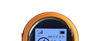
If you are looking for a GPS tracker for a mushroom picker, look for inexpensive hiking models. Such a lightweight compact device with a small display is also called a return or GPS compass; many models are made in the form of a key fob. The entry point into the forest can be entered into the tracker's memory by marking it on the map. In the direction of travel, it is advisable to mark additional key points of the route (departure from the clearing, branching of the path, a noticeable landmark). Different models can store from 3 to 24 points in memory. The tracker display shows the current time, distance traveled, average speed. An arrow on the screen indicates the direction in which to move to return to the set point.

GPS recording of your path in the forest can also be done using a number of smartphone apps. These include the free I'm Going Home program for Android 2.1 and higher devices. TRACKER GPS has a free version with the ability to store two points and a PRO version with an unlimited number of points.
Before you buy GPS for the forest, compare several models, paying attention to the following characteristics:
- battery life;
- number of waypoints;
- availability of additional functions: stopwatch, pedometer, display backlight, flashlight;
- execution (for a forest, a moisture-proof all-weather case is preferable).
Travel GPS tracker with built-in digital compass is easy to use and reliable. With its help, even a person who does not know how to use an ordinary compass and navigate the terrain can easily get out of the forest.
Today, for Russian consumers, the domestic market offers a huge number of modifications of GPS-navigators that they can use for hiking in the forest and fishing. The most sought after, ideal for hiking, are Garmin branded devices. Navigators can be of several types:
- software;
- tourist (pocket);
- automobile, etc.
The best navigators for the forest have a huge number of functions, the main of which are:
- ability to choose the most active route;
- the ability to work without interruption for a long time (at least 20 hours);
- ability to work with the software "Roads of the Russian Federation", etc.
How to choose the best navigator for the forest, which is the best?
When choosing a navigator for forest walks, every mushroom picker should pay attention to devices that are easy to use. They must have the following characteristics:
- small dimensions;
- light weight;
- capacious battery;
- the ability to find the way back in record time;
- assistance with orientation on the terrain;
- be equipped with a memory card, thanks to which the device can remember a large number of places;
- be equipped with the maximum number of road maps;
- the ability to make short routes;
- equipping with a highly sensitive GPS receiver, etc.
Navigator for forestry and fishing
 Garmin's GPS navigator for forestry and fishing will help people to minimize the time on the upcoming route. This device can be especially useful in unfamiliar areas, which are fraught with many surprises and road obstacles. The manufacturer of navigators Garmin presented several new series for forestry and fishing for Russian consumers:
- eTrex;
- Oregon;
- GPSMap, etc.
All of these devices are ideal for pedestrians due to their very compact size, night time display and affordable cost.
Navigator for android for the forest
Despite the fact that new gadgets are constantly presented on the domestic market, it is rather problematic to find a navigation application in them that would be convenient and multifunctional. Many mushroom pickers install third-party software on android, which is freely available. A modern navigator for android for the forest must first of all be able to plot the most optimal route and guide its user along it. He should be able to download a large number of road maps and be able to work with them.
Forest Navigator for iPhone
 For owners of iPhones, special software is available that determines and shows on the screen the road to any point in the Russian Federation. The user of this technical device, going on a forest walk, will always have access to the selected lane of the route, on which all traffic situations are determined and indicated. On the screen of the iPhone in automatic mode, switching between night and day modes is carried out, since the program always takes into account the current time. The convenient search system of the navigator will allow iPhone owners to quickly draw up the upcoming route and not be distracted from the search for mushrooms by carefully studying and memorizing the area.
Garmin navigator for forest
Garmin GPS navigators designed for the forest are ergonomic and compact. With this device, the mushroom picker will be able to start working without taking off his gloves, which is very important in adverse weather conditions. Convenient joysticks allow users to quickly move the cursor around the screen while entering data and selecting a route. Joystick lock will not allow the device to involuntarily start its work, even with strong physical impact. The robust housing of Garmin devices is reliably protected from any mechanical damage and can keep its original external data for a long time.
Car navigator in the forest
 Some mushroom pickers who have their own transport try to use car navigators when visiting the forest. These devices are not very suitable for "quiet hunting", as they are tuned specifically to the highways of the Russian Federation and can provide their owners with inaccurate data, especially if it will be necessary to plot a route in a dense forest. Car navigators are equipped with maps that allow drivers to determine the distance of a car from a particular city or street. They also provide data to the car enthusiast about all major country roads in Russia. He is able to warn the driver about all traffic jams that are present on his route.
How to use the navigator in the forest?
Every avid mushroom picker should use a portable forest navigator during the "quiet hunt", thanks to which he will not stray from the chosen route and will not get lost. Before turning it on, it is necessary to study the instructions that will help the user to correctly configure. It is important to install all necessary software on this device in advance. After starting the application, a map of the area will appear on the navigator screen. Special prompts that will regularly appear on the monitor will help you customize it directly for yourself. The mushroom picker must enter in a special section of the menu all the requested data that may be useful to him later. As soon as the information input is completed, the mushroom picker can set a specific route and follow it throughout the trip.
And again the cold autumn rain rustles evenly and monotonously on the slopes of the huts. There is no end to it, no edge. Around is a completely wet night, completely alien to a human being and an unkind, silent, endless forest, but for some reason we are comfortable and calm.
The main thing was done: we managed to build a shelter before complete darkness - to erect two lean-to huts opposite each other with a light canopy thrown between them. A node was co-equipped under it. The rain practically did not flood the fire, which was difficult to light, although individual drops still seeped through the dense frame and spruce branches of the canopy, but hissed powerlessly, dying in the flame.
So, we changed into dry clothes, hung our wet clothes to dry, and got down to cooking dinner. About these two most important elements of survival in a wet and cold autumn forest - about changing clothes and a diet - we, if possible, will talk later, but for now we will settle down on unfolded rugs, which are now warmer and softer than any feather beds, and conduct a friendly conversation to the sounds rain and fire.
We have time to relax and think about how we got to this life. Just a joke, but we got lost, and this can become one of the main reasons for an unplanned wet overnight stay in a hunting raid.
In cloudy, rainy weather, you can get lost in any flat landscape that does not have obvious landmarks: in the steppe, in reeds and reeds, in river and lake channels, and even get lost in the forest, in the taiga, as they say, God himself ordered. True, in the modern world, filled with all kinds of technical achievements, it is possible to get into such a situation only because of one's own frivolity and unpreparedness. Or through inattention, which happened to us more than once.
We have already said that a long-distance hunting raid without a hatchet in a backpack is not serious. So, another omission in preparation for the hike is the absence of a map, compass and navigator, these three items in their totality. Let's go in order.
The most commonplace knowledge of a map of the area is an important precaution that helps to minimize the risk of getting lost for a long time and seriously under any circumstances. The most complete frivolity is to go into a raid without examining a kilometer map, or even better - a military five hundred meters. Well, firstly, it’s just interesting to know where you are going and where what is: rivers, streams and swamps, natural boundaries and forests, glades and clearings, settlements and roads, and in the end the boundaries of those lands in which you have a voucher or a license. The study of the topography of the area is generally a fascinating exercise.
And secondly ... Suppose you realized that you got confused and were able to determine the cardinal points. And then what? Let's say you know that you need to go east, but what is there, right along the line? Maybe a swamp? Or a river with unknown fords? An ordinary map - a good old kilometer - allows you to capture with a glance at once all the details of the landscape on a huge area and instantly outline the path for kilometers ahead. Therefore, the card should be not just in the visual memory, but also in the pocket. By the way, it is very useful to study the satellite map in maximum resolution before going out to unfamiliar lands (if, of course, you can find one).
One day in the fall of 2013 at sunset, not knowing the details of the terrain and not having (by negligence) printouts of a satellite map, I left the taiga almost to the hunting base itself and ... ran into a colossal felling of the forest. I have never seen anything more grandiose. I knew where the base was, heard it, saw from the navigator that it was three hundred meters away, but could not get through. The dump was so dense, dense and extensive that I was completely exhausted and was already preparing to look under the tree trunks for a place to spend the night in order to rest and recover. But I was suddenly covered with the strongest anger at myself, and with this anger I climbed over the blockage, risking breaking both my legs and neck, and went out to the base.
And then, already at home, I opened a satellite map in Yandex and - please, here it is, that very grandiose blockage. Eh, if only to see it earlier!
A compass is an absolutely reliable thing in a campaign, which served us all faithfully long before the advent of navigators, but in a forest where there is no way to take an extremely clear azimuth by some obvious reference point, with a compass you can only go "in the direction."
Not later than a couple of years ago, on a site already known to us, my friend came out to the car from a swampy, incredibly dense and confused floodplain of a small river. By compass. And he knew that he would definitely come to an abandoned dirt road that stretched almost parallel to the floodplain. I just didn't take into account that there are several forks on the road, similar to each other, like twins.
He got to the road, but even seeing the sun that had peeped out by that time and holding a compass in his hands, he could not understand where he was: to the right or to the left of the car. It turned out that he went far away at all - he didn't even take the radio. Now imagine yourself in his place: there is a road under your feet, but where to go along it? Of course, my friend knew that if he went to the right, then, even without finding a car, he would come out to the cordon by nightfall, but this was not an option!
In general, while waiting for a friend at the car for a very long time, I heard only his third shot and gave a response signal. He later explained that he was trying to find his way around the tracks on the road: if there is a tread mark on the car, it means that we were passing here and we had to go to the left. But the forest track, with little use, overgrown with dense short grass, did not retain any information on this matter.
This I mean that it is almost impossible to get to the desired point in the forest using only one compass, not knowing the terrain and not seeing the map. Unless you're going to circle.
Navigator ... It is necessary to be able to walk without it in the forest, but it is no longer possible not to use it in the forest today, when the 21st century is outside. Just in no case, do not forget that the navigator is not a panacea and may very well fail, albeit extremely rarely, but, as they say, aptly. Let me give you two examples.
My friend, an intelligent and experienced forestry hunter, does not go without a navigator. But one day he admitted carelessness in handling this device - he set the scale too small - and for several hours he spun in a small area of \u200b\u200bthe forest. The problem was that the cursor almost did not move at this scale and covered the track that he himself was drawing. A friend walked an hour, the second in the right direction ... What nonsense ?! For a long time I had to go to a fork in the road, but the forest is still the same. Zoomed in - honest mother! The track is as if a spider has woven a web - circle by circle! This is the same inattention that I mentioned at the very beginning.
My navigator just glitched once. The device suddenly, in a completely incomprehensible way, confused north and south and led me straight into the swamps, and not onto the road. Maybe it was not the gadget that was the case, but some kind of failure occurred in the incredibly thin system of ground stations and satellites. But be that as it may, and I spanked like a zombie, according to the target designation given to me by a smart machine, and, if not for my partner, they would only have seen me. Unlike me, he knew the area and after a while was surprised that it was decreasing: the powerful primary forest was gradually replaced by a frail, low-boggy forest. My partner caught himself, took a compass out of his pocket ... and I learned a lot of interesting things about myself. And at the same time about GPS.
If all the troubles that could happen to you happened to you (the sun is not visible, the map is soaked, the compass is lost, the navigator has "died"), be guided by the wind. In autumn, our winds are usually northerly (noticeably cold) or northwestern (softer, more humid). If you look closely, you can see the direction of movement of even continuous and even clouds. Here is the direction of its movement and be guided.
Modern apps can help you find your way wherever you are: in a metropolis, out of town, in a forest, or even in a shopping center. In addition, special programs will help you find out where your children are.
Pointing finger for mushroom picker
The app store has a series of programs for navigating the forest. For example application "Navigator. I'm going home", as the developers assure, it works without an Internet connection, using a GPS signal. For example, it will help you return to the starting point from which your route began. Where to hide, the application will prompt with a voice. It will save the necessary routes in the map, for example, a mushroom or berry place, and help you return to it again. There are several versions of the program.
Another application Location Detector (GPS)according to the developer, it can also work without an Internet connection and is suitable for use in forests and mountains. It allows you to independently choose the best map, as well as a navigation method: an arrow or a voice. You can save the places you want, there is also a compass in the functionality. It is also possible to send an SMS message with your location and coordinates.
In the direction of the compass arrow
Many travel users also download compass apps. For correct operation, you must have a phone model equipped with a magnetic sensor.
application "Compass 360 Pro Free", according to the developer, it works properly and accurately anywhere in the world. You can use it like a real compass, it does not require an internet connection and supports many languages.
Similar application "Compass",as the developer assures, it will also allow determining the magnetic and true course, location and address. Displays your position on the lock screen.
We are looking for a way out of the shopping center
Pedestrians can navigate in the city, for example, the application "Maps: Transport and Navigation", it will calculate the time of the route, has voice prompts. He will indicate how to get to the desired place by transport, will show the nearest restaurants, cafes, gas stations and pharmacies.
Similar application "Yandex maps" also has pedestrian navigation, which takes into account the passages between houses, paths in squares and parks.
Another assistant for pedestrians can be an application "2GIS: reference book and navigator". Works without internet. In addition, the program will help you quickly find the entrance to the desired building and not even get lost inside the shopping center, showing the desired store or the nearest ATM.
Children under supervision
To track the location of a child, there is, for example, an application "Family GPS Locator My Family"... It allows you to set a child mode that will not allow the child to turn off geolocation and change the settings. You can see the history of movement on the map, as well as create places and receive notifications when the child arrives or leaves it. Works with GPS.
Similar application "LifeSign - Family Locator", on the assurance of the developer, it will show on the map where your child is. And you will also know the weather in that place, the level of charge and the availability of mobile communications. It can work even without a GPS signal.
Hunters, fishermen, tourists and even mushroom pickers have recently been increasingly using the navigator to hike into the forest or go to a pond. The fact that this convenient and functional gadget will not let you get lost is understandable. But after all, it is possible to mark on it both the usual places of fish, and mushroom places, so that next year the basket and the cage do not remain empty.
There are, of course, all kinds of applications for androids, phones, smartphones, tablets and other devices, but, firstly, it is somewhat difficult to choose the best option from among them, and even if it works out, they can fail on a long hike. Phone chargers are not installed on a birch or pine tree, and at the most crucial moment your gadget may simply refuse to work. A good navigator not only holds a charge much longer, but makes it possible to quickly change the battery and generally put in ordinary batteries. In addition, all these applications will not provide such an amount of necessary and useful information as a navigator for a trip to the forest.
Types of travel navigators
Separation to the point of banality is understandable, which is good.
- Simple. Black-and-white little-functional navigators. Most of them don't even have the ability to download new maps. The maximum they can do is mark a few points and plot a couple of routes on an existing map. It is not recommended to take them on a multi-day walk, but it is quite possible to mark the mushroom spots around the dacha or the favorite sites of large bream, carp or catfish.
- Difficult. There is literally room for imagination on these devices. But this space must be approached, if not carefully, then very thoughtfully. Here you will be offered not only a large selection of maps that can be constantly updated, but also an altimeter, compass, barometer and even a pedometer. Not to mention building a route and memorizing the path already traveled. Without certain skills, you can get confused.
Depending on what exactly you want from the purchased device and you need to choose. To mark the lake so as not to come from fishing without a catch, or to stake out a small birch grove, where there are a lot of stumps - you do not need to overpay several times for this. And if you like to leave the blessings of civilization a couple of times a year and go admiring unfamiliar forest expanses or picturesque mountains for a week and a half or two, then you should shake your wallet and choose an advanced multifunctional navigator for tourism.
Navigator for fishing and hunting
This issue has already been covered somewhat above, so there is no point in repeating it. But still. Fishing and hunting are different. If you are doing these types of outdoor activities close to home, then soon you won't need a navigator either. But if you go to a new reservoir or to a completely unfamiliar forest, it is better to worry in advance that your navigator has a map of this area with all the details and an approximate route to a couple of nearby settlements.
Navigation app for android
And we managed to touch on this issue, but here it is worth deciphering a little. There are a lot of navigation applications. If someone advised you a certain thing, and you completely trust the advisor, you should still drive such a navigator a little, after downloading it to your android and always before going into the forest. In most cases, additional, but very useful functions are absent in the initial version, and they will have to be downloaded and installed separately, often for an additional fee. And most importantly, do not forget to make sure that the battery of the gadget is 100% charged before going into the forest.

Navigator for iPhone
This option will be better than android. Firstly, because a good application has updates online, and you will always know where you are. Secondly, the functionality of such applications is much better, and the connection, if the satellite is connected, is many times better.
Navigator Garmin
The most affordable model of navigators among hunters, tourists, fishermen, mushroom pickers and simply amateurs going on a hike. However, the cheapness this time does not mean the lack of quality. The device meets almost all requests. Small in size, which makes it easy to handle with one hand without connecting the other. The case is durable, waterproof and non-slippery. The joystick is convenient even for working with gloves and has a locking function, which is very convenient in order not to accidentally confuse the route or other indicators. The battery is designed for uninterrupted operation for 20-24 hours. The device is equipped with all sorts of useful functions and add-ons. In the search for mushrooms, fish or the desired path, this is a very good helper.

An absolutely necessary device in the car, it is absolutely useless to argue with this. It will show you exactly how to get to the forest and from that moment you can safely turn it off. It is impossible to navigate in the forest using a car navigator. And not only because the car will not pass there, it will squeeze through in some places. And because he is not programmed for this. It is usually loaded with a map of streets, squares, lanes and suburban highways. They can advise where it is better to go around the traffic jam. Forests and the surface of the lake are indicated by a solid blue or green spot on car navigators, and for a mushroom picker or fisherman they are just like “white spots”.

How to choose a hiking navigator
Before you go to a specialized store, and in the store itself, you need to pay attention to some parameters of the selected device.
Physical parameters
The size and weight of the navigator plays an important role if you have a long walk on rough terrain ahead. Of course, he will not pull his arms or shoulders, but the ideal option would be a device that fits in the palm of your hand and fits into the most convenient pocket, from where you can easily get it at any time without slowing down. There is no need to remind that it should be well protected from moisture, dirt, dust and other troubles.
Display
The color display is not only beautiful, but also much more practical in terms of reading and understanding the displayed information. However, there are two rather significant disadvantages here. Such a screen consumes a lot more energy, which means that you have to worry about additional batteries. On a sunny day, you will either have to look for a shaded corner or cover the screen with your hands, since the contrast can play a very unpleasant joke. The disadvantages are not so significant, but anyway, if you plan to use the navigator not on long hiking trips, it is quite possible to get by with a black and white display.
CPU
For avid tourists, who have multi-day hikes ahead, the question of processor power is not worth it. The more powerful the better, there is nothing to argue about. Standing in one place and waiting for the navigator to process information on such trips is not only boring, but you can also get out of the schedule.
Memory size
The same principle applies here as with processor power. The more memory, the more maps can be loaded into the navigator. The ideal option would be a device that allows you to use additional media such as micro SD. Well, the minimum memory size should be 1 GB.
Charging
This is one of the first questions a seller is asked when choosing a travel navigator. And again, the principle should be: the more the better. A device whose passport states that it lasts less than 15 hours should not even be considered. On a long hike, you will have to change the batteries more than once or twice, but drag them with you, and to the city, because throwing out charging cells in the forest is to harm nature, it is not very pleasant.
Cartographic capabilities
In addition to the fact that the navigator shows you your location in a certain area of \u200b\u200bthe terrain, it is also good that it allows you to update the maps loaded into it. This will help to reduce the error of indicators and will enable the user to make the necessary adjustments.
Case and cover
A cover is desirable. Especially if during the trip the river crossing is planned, during which the opportunity to wet the luggage increases significantly. And the navigator is also not insured against falling from a height or on an untimely turned up stone. Even a high-quality housing of the device itself may not withstand the overloads of a difficult tourist route, so extra protection will not hurt.
The requirements for the body itself were described above, but it is worth repeating them:
- Strength.
- Tightness.
- The presence of softening and anti-slip elements.
We can safely say that in some conditions you will appreciate your prudence.
It is better to go on a multi-day hiking trip with an experienced guide, or a person who has been to these places more than once and knows some signs and relief features that allow you to quickly determine the location of the group and correct the route in case of deviation from the planned paths.
However, a good travel navigator can help out too. The main thing when buying is to adhere to the parameters and requirements listed above and, before going on a trip, thoroughly study all the capabilities of the device, load all the necessary applications and functions into it and exercise a little in familiar terrain. And then your journey will not be overshadowed by an unexpected unfamiliar landscape, which, instead of striking with its beauty, will frighten you with the realization that you are lost.