Navitel is the leading paid digital satellite navigation software for illustrating traffic on paved routes. Navitel was released by the Russian company "Center for Navigation Technologies" and achieved great success, collecting a lot of positive feedback from users, especially on the latest versions of the program, which have significantly improved their quality. The program is available for communicators based on iOS, Windows Mobile, Windows Phone, Java, Bada, Android, etc., as well as for PDAs.
Using the program and getting directions to Navitel is not particularly difficult. First, turn on the GPS (if you use a phone, everything will already be turned on in the navigator). We launch Navitel itself. When it turns on and loads the map, it may not be showing where you really are. Then, for the display to be more correct, you need to catch the satellites. Select the green satellite dish icon (if the icon is yellow, it means that the program has not yet connected to the satellites). A menu will open, select "satellites". In the window that appears, satellites will be shown, some of them are in search, some are still showing up. The determined satellites will light up green.
Keep in mind that Navitel catches only in open areas, which means that if you are indoors and there is at least one floor above you, satellites most likely will not be found! In the car, however, this is not a problem - there is no floor above.
Press the "Back" button and return to the main page - with the help of satellites, the location should be determined correctly. Now you can start building a route in Navitel.
How to create a route in Navitel from city to city
First, let's see how to get a route directly from city to city (or just from one place to another). This can be either the place where you are now (then the route is laid to the destination), or any other. One way or another, initially we need two points.
Increase the scale as much as possible and poke your finger at the starting point. We press the "Save" button and save the waypoint, give a name for it - "Start". Now we scroll the map to the final destination and do the same, name the second point "Finish". Scroll back to the starting point "Start", make sure that it is exactly in the middle of the screen. Press "Find", indicate that you need to search for Waypoints. We find "Finish". Select by poking your finger (stylus). A button or menu item (depending on the version of your Navitel) "Show on map" will appear. We poke. We will see the finish point, that is, the destination, and click "Go" at the top of the screen.
A route will be laid from one point to another. But it is not a fact that it will be optimal, so the option with several points is preferable.
How to make a route in Navitel with several points
We are not in a hurry to delete our route! Let's save it (first, "Menu", then "Route", then "Route Properties"). Click on the button depicting the list below. Select the menu item "Export". We save the file, for example, under the name "Our first route".
Now close Navitel completely and launch it again. When asked whether to continue the previously laid route - we refuse!
Now we will use intermediate points to correct the route. Let's say we know that the best way for us from "Start" to "Finish" will be across the road that Navitel ignored.
We then look for this road and put a point on it, say, "Road", save it; Now again in "Find", we are looking for waypoints, select our point "Road"; Then "Show on map"; The map with the "Road" point will open and now press the "Enter" button!
All! The route will be laid so that the path from "Start" to "Finish" will pass through the "Road". And if, in addition to the road, you need the "Ravine", and the "Shop", and other points, then it's not a problem to put them in the same way! As you can see, everything is very simple - enjoy your navigation!
(adsbygoogle \u003d window.adsbygoogle ||) .push (());
Navitel - the leading paid digital satellite navigation software to illustrate traffic on established routes. Navitel was released by the Russian company "Center for Navigation Technologies" and has achieved great success, collecting a lot of positive feedback from users, especially on the latest versions of the program, which have significantly improved their quality. The program is available for communicators based on iOS, Windows Mobile, Windows Phone, Java, Bada, Android, etc., as well as for PDAs.
Using the program and getting directions to Navitel is not particularly difficult
- At first turn on GPS (if you use a phone, everything will already be turned on in the navigator).
- We launch Navitel itself.
- When it turns on and loads the map, it may not be showing where you really are.
- Then, to make the display more correct, need to catch satellites.
- Select the green satellite dish icon (if the icon is yellow, it means that the program has not yet connected to satellites).
- A menu will open, choose " satellites«.
- In the window that appears, satellites will be shown, some of them are in search, some are still showing up. Determined satellites will light up green.

Keep in mind that Navitel catches only in open areas, which means that if you are indoors and there is at least one floor above you, satellites most likely will not be found! In the car, however, this is not a problem - there is no floor above.
Press the "Back" button and return to the main page - using the satellites, the location should be determined correctly. Now you can start building a route in Navitel.
How to create a route in Navitel from city to city
First, let's see how to get a route directly from city to city (or just from one place to another). This can be either the place where you are now (then the route is laid to the destination), or any other. One way or another, initially we need two points.
- Maximum zoom in and point a finger to the starting point.
- We press the button " Save"And save the waypoint, give it a name -" Start«.
- Now we scroll the map to the final destination and do the same, give the name to the second point "Finish".
- Scroll back to the starting point " Start“, We want it to be exactly in the middle of the screen.
- Click " To find“, Indicate that you need to search for Waypoints. We find "Finish". Select by poking your finger (stylus).
- A button or menu item will appear (depending on the version of your Navitel) " To show on the map«.
- We poke. We will see the finish point, that is, the destination, and click at the top of the screen “ To go«.
A route will be laid from one point to another. But it is not a fact that it will be optimal, so the option with several points is preferable.
How to make a route in Navitel with several points
We are not in a hurry to delete our route! Let's save it (first, "Menu", then "Route", then "Route properties"). Click on the button depicting the list below. We select the menu item "Export". We save the file, for example, under the name "Our first route".
Now close Navitel completely and launch it again. When asked whether to continue the previously laid route - we refuse!
- Go to the Menu, then “ Route", Then" Route properties«;
- Press the button representing the list;
- Menu item " Import«;
- We find " Our first route"And select it again - it will open.
Now we will use intermediate points to correct the route.... Let's say we know that the best way for us is from " Start"To" Finish"Will pass through the road that Navitel ignored.
- We then look for this road and put a point on it, say, “ Road“, We save it;
- Now again in " To find“, We are looking for waypoints, we select our point“ Road ”;
- Then “ To show on the map«;
- A map with a dot " Road"And now press the button" Stop by«!
All! The route will be laid so that the path from "Start" to "Finish" will pass through the "Road". And if, in addition to the road, you need the "Ravine", and the "Store", and other points, then it's not a problem to put them in the same way! As you can see, everything is very simple - enjoy your navigation!
If you are unable to do something on your own, then we advise you to contact an ambulance computer help - pchelp24.com, reasonable prices, experienced specialists, free call and diagnostics.
In recent years, the market for car gadgets has been filled with more and more useful and functional devices designed to simplify the life of car owners and improve traffic safety. The best engineers in the world are working on creating unique devices designed primarily for drivers. One of the demanded "miracles of technology" is a car navigator, the main task of which is to position the device in relation to a map of the area, and to speed up the process of finding the necessary place (houses, streets, cafes, etc.).
It would seem that until recently the map was the best assistant to the driver. But, despite the accuracy of the information, it is inconvenient to use such a "hint", and the very process of finding the right place took a lot of time. With the advent of the navigator, the need to use paper maps has completely disappeared. All that is required is to press a few buttons, getting a picture of the current position and the future route.
But many "newly minted" owners of such devices face a number of difficulties. It is not always clear how to use the navigator and what actions to take to fine-tune it. Let's consider these points in more detail.
How to use the navigator
Buying such a useful gadget is only the first stage. The next step is to learn how to use the navigator, correctly turn on and set the required route. The package, in addition to the navigator itself, includes charging and a manual (instruction) for using the gadget.
To begin with, it is worth examining the contents of the documents, after which you can proceed to setting up. Here the sequence of actions is as follows:
- Power on the device.
- Wait until the navigator loads and a picture appears indicating the start of the search for a satellite. Immediately after setting up the signal, the word “Position” appears on the screen. Now you can find out your own position on the map and see the road where the car is.
- To use the navigator and maps, enter the "Menu", and then into the "Settings". There will be a section "Map" where you need to decide on the display principle. There are two options available - rotation in motion or north up. It is better to choose the first option, which is more convenient to use.
- When determining the route, to move to a specific point by car, go to the "Menu", then choose one of the options. Search is possible by coordinates, through waypoints, by the closest places, by address or by favorite places.
- In the fields that appear, you must indicate the street, house and name of the settlement. The input process is straightforward. It is enough to enter the first few letters, after which the program displays the appropriate options. As soon as the exact address is registered, it remains to give the command to the device "Go". If the program, for any reason, does not find the specified house or street, you can specify the street closest to it, with the building number.
- Wait until the route is formed (it takes a couple of seconds), then move to the goal on the map.
As you can see, using the navigator is not that difficult. But what to do in case of unforeseen circumstances? For example, the device has plotted a route, but it does not fit, or, in the direction of travel, you need to drive to another point along the way. In such a situation, the already formed path should be corrected. Here the sequence of actions is as follows:
- Slide the map to the desired destination. Next, click on the point of interest, and then come up with a name for it.
- Click on the "Find" link, then head to the "Waypoints" section. Now all that remains is to choose a suitable city and click on the "Show on the map" button. After performing the above manipulations, a map of the settlement with the required place opens. At the end of the setup, it remains to click on the "Enter" button.
Now the program recalculates the previously set route, after which the distance to the destination point is written and the time on the road is indicated. All that is required is to remember to save the map after making changes. This is done by clicking on the special button "Export".
Learning to use the navigator is a matter of a few minutes. Having learned the basics, you can choose a suitable route, and exclude certain sections from it. To do this, click on the link "Avoid when planning a route", then set the required parameters. So, you can "teach" the program not to take into account toll or dirt roads, highways and other types of routes. If desired, it is easy to find out the address of nearby cafeterias, hotels or gas stations. To do this, go to settings and mark POI.
When the gadget is connected to the Internet, the user has access to current data on traffic jams. Thanks to this option, you can save unnecessary time and avoid the traffic jam in a timely manner.
Rules for installing the navigator in the car
Having learned how to use the navigator, you can proceed to attaching it to the car. To make it easier to use the device, you should follow a few rules:
- Make sure that the antenna of the gadget is not covered by metal elements.
- Place the navigator so that, while driving, it does not block your view.
- Calculate the cable length. It is important that there is enough power to charge the device.
- Position the gadget so that the sun's rays do not fall on the display.
- Adjust the angle of the screen so that you can follow the route.
The navigator is a constant assistant for drivers, fishermen, hunters and mushroom pickers. With its help, you can easily plan a route and find the desired place. If you know how to use a navigator, many tasks become on the shoulder, and tools such as maps or a compass become irrelevant.
Video: How to get directions on the Navitel navigator
If the video does not show, please refresh the page or
Navigator "Navitel" is a convenient software that searches for the shortest routes on the map. It has a “voice prompt” function, which allows the driver not to be distracted while driving on the navigator screen. The principle of operation of this device is quite simple, it will not be difficult to learn how to use it.
Navigator "Navitel" has a full screen mode, useful tooltips, supports 2D, pseudo 3D. It implements scaling and fast scrolling of maps, it is possible to choose the orientation of the map: in the direction of the route, movement, north. This program performs the following tasks:- location determination with display on the map;
- automatic and manual routing;
- calculation of travel information, displaying it on the map;
- search for objects;
- route recording, displaying as a track.


- nearest on the map;
- by the address;
- waypoints;
- loved ones;
- history;
- by coordinates;
- Navitel sms.
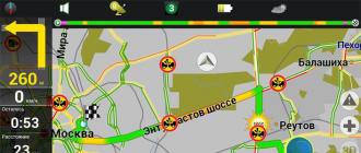
You should select the menu item "by address", after which the system will determine your current location. Now you should specify the address where you need to go: select the country, city, street, house number and press the "go" button at the top left of the screen. The program will immediately plot the shortest route, marking the destination with a flag.


- map rotation: you can fix the map north up or set the mode of its rotation in the direction of travel;
- navigation: here you can select a mode of transport, a route (in a straight line, on a road; short or fast), set a warning about a maneuver, the degree of sensitivity of leaving the route;
- additional settings: in the "device" tab you can adjust the sound, clock, power.

Navigator "Navitel" can be used by drivers of vehicles, cyclists, even pedestrians. This device makes it much easier to find the shortest route to the desired point, and working with it is not at all difficult.
Navitel is one of the leaders in the segment of paid navigators in the CIS market. The program was created for digital satellite navigation and traffic control along a given route. The utility was developed by the Russian company "Center for Navigation Technologies" and received a lot of praise from users, collected numerous awards. It is especially worth highlighting the latest versions of the navigator, because it is constantly being improved.
Important! The software is distributed on the basis of mobile platforms or together with a ready-made device, where the price is included in the price of the device.
Getting directions is easy
How to get directions on the Navitel navigator:
- Activate the GPS service (if you are using a mobile device, everything is turned on by default in your navigator).
- Start Navitel.
- Wait while the system turns on and downloads maps, it happens that an unreal user location appears.
- In case of problems, you need to establish work with satellites.
- Click on the icon in the form of a green satellite dish (when it is yellow, the program has not yet established a connection with the satellite).
- Open the menu.
- Find "Companions".
- In the section that opens, satellites are displayed, some have not yet appeared, others are fully available. Found options are highlighted in green.
Important! The program is not perfect and is only able to find satellites in open areas. Indoors, in underground parking, it may be difficult to find points. It is best to set up the program outdoors.

Creating a path from city to city
The first thing to consider is the way to create a path from one settlement to another (from city to city, from point to point). Places can be not only the coordinates of the current location (road to the final destination), but also other options. One way or another, at least two labels are always needed.

How to get directions to Navitel:
- Select the largest possible scale and use your finger to find the starting point of the path.
- We select "Save" and create a label, which we call "Start" (any name of your choice).
- Then we scroll the map to the final destination and do everything the same, but the name of this point is "Finish".
- Scroll back to the initial "start" mark, do everything so that it is exactly in the middle of the display.
- Select the "Find" icon and indicate that you want to find "Waypoints". We select "Finish" using the touch screen and finger.
- An icon or interface item (depending on the software version) "Show on the map" will be displayed - click on it.
- You will see the end mark on the screen, this is "Finish".
- Tap Drive on the screen.
- The program will lay a road from one point to another, but it is not necessary that it will be optimal, therefore it is recommended to use several points at the same time.
Creating a route using multiple points
If you have already created a path using only two points, then do not rush to delete it. Save everything (go to the "Menu", then to the "Route" section and then to the "Route Properties").At the bottom, click on the icon in the form of a list. Find the Export menu. Save this file, giving it any name, for example "Option 1".
How to set up a route on the Navitel navigator:
- Close the Navitel program completely and start it again. When the utility asks if you need to continue with the previously created option, you need to answer - no.
- We go to the "Menu", and then to the "Route" and "Route Properties".
- Select the list icon.
- Click on "Import".
- Select the previously created route "Option 1" and reopen it.
- Now you need to use additional points to correct the previously done route. For example, a driver knows that it is better to drive from beginning to end across the road that Navitel ignored.
- We are looking for the desired road, put a point on it and call it "Road", save the result.
- Then again in the "Find" we select the waypoints and use the created "Road".
- Click Show on Map.
- The map will take into account the "Road" point, now click on "Enter".
It's simple, now the path will be designed so that the route from the beginning to the end will pass through an additional point. You can add not one, but several auxiliary points at once, for example, shops, gas stations, etc.