As you know, in most ordinary car navigators, only one navigation program is installed and, of course, this is a program for navigating routable vector maps (for example, "Navitel Navigator", "Avtosputnik", "CityGuide", "iGO8", ...), designed for use on a car within settlements and highways. But is the vector map navigation program always sufficient to arrive at the desired waypoint?
1. On the disadvantages of conventional GPS navigators with one navigation program
If you are an inveterate city dweller and leave the asphalt road only for a short stop on the side of the road, then probably yes. But practically any car has to be driven not only on the asphalt roads of cities and towns. Sometimes we, the inhabitants of megalopolises, want to get out into nature - to relax by the river or lake, fish, hunt, go for mushrooms. And, of course, it is more convenient to do this by car, so much so that you can get closer to the resting place on it. The programs "Navitel Navigator", "Avtosputnik", "CityGuide", "iGO8", which are supplied as part of conventional GPS / GLONASS navigators and use vector maps, will only partially help us here - they will drive us along an asphalt or dirt road, only to the outskirts of the populated point, the beginning of a forest or an exit from a busy highway. But you won't go far further on vector maps, because:
- woodlands, steppes, fields, deserts are shown simply by a polygon of a certain color, in which forest glades, clearings, edges, paths are not visible;
- the concept of terrain relief is completely absent: mountains, hills, ravines, elevation changes;
- trails, roads with seasonal passability, roads with conditional passability are not shown;
- swamps and swamps are shown with very approximate outlines.
All these features impose very serious restrictions on the possibility of using programs for vector maps in the field (such as Navitel Navigator, Avtosputnik, CityGid, etc.), and having only one of these programs in the car navigator (or even all together), then you will have to go either on a paper map, or wherever your eyes look.
And here, for sure, each of the owners of GPS-navigators will ask the question: “There is a road, the car is driving along it, so why does the GPS-navigator not show this road, or where it leads, or the surrounding area? It was not for this that the navigator was bought, bw. ride on a paper map !!!Is there really nothing you can do?"
Sure you may! - for this programs are required in the car navigator OziExplorerCE and SAS4WinCE, which were created to solve navigation problems in the field.
2. Why in the auto navigatoroziExplorerCE and SAS4WinCE programs
The main difference and advantage of the OziExplorerCE and SAS4WinCE programs is the ability to use various raster maps in the auto navigator: digitized topographic maps, satellite images of the earth from space (today, almost 100% of the earth's surface is captured from space at different scales, many areas with detailing to individual trees! - and all this is in the public domain), digitized historical maps (give unlimited space for archaeologists and treasure hunters as accurately as possible to determine the location of ancient settlements, treasures, places of battles, burials, ...).
Let's consider a few typical examples when the OziExplorerCE and SAS4WinCE programs can be very useful, while programs like Navitel Navigator are simply powerless.
Navigator for out-of-town rest
It will allow you to find and mark a cozy deserted beach, an interesting place to relax, bw. later come back here again, tell your friends about it, show a convenient way.
With a navigator for mushrooms, a navigator for hiking in the forest
The navigator will allow:
Imagine you went mushroom picking by car. We drove into the forest, and after driving along a dirt road for some time, we stopped somewhere, took a basket and went through the forest in search of mushroom spots - from tree to tree, from glade to glade. Found a mushroom place - mark it on the raster map in the navigator - next year you can easily come back here again! Well, the basket is already full, it would be necessary to return to the car, but where is it, how to find it? That's right - before you left the car, you marked its place on a raster map and now finding it in the forest, even in the dark, will not be the slightest bit of trouble! And the route of movement through the forest can also be recorded.
Fishing Navigator
- It will facilitate the search for new interesting places, passages and passages to them.
- Allows you to save the coordinates of successful or unsuccessful fishing spots and return again after a while.
- Fishing often happens to stay up late and come back in complete darkness. The navigator will allow you to save on the map the track of the fishing road along which you were driving in the daytime, and will easily guide you back along this track at night, minimizing the likelihood of getting stuck in the mud in the night forest.
Hunting Navigator
- It will help you remember the coordinates of the parking lot, so that you can return to it later without much wandering.
- Allows you to mark the places of installation of baits, animal trails, holes, dens, hunting lodges.
- It will facilitate the search for places that are promising in terms of hunting.
- Save the track (route) of movements in the forest.
Navigator for searchers, archaeologists
The capabilities of modern navigators with the program for raster maps OziExplorerCE, open endless spaces for the activities of lovers of excavation, searching for burial places, treasures, etc. Suffice it to mention the possibility of the simultaneous use of ancient historical maps, together with modern topographic ones, for accurate detection of the sites of ancient settlements, battles, burials, historical battles and natural disasters, ...
3. Programs for navigation on raster maps
So, if you are not alien to the spirit of autotravel, if you, at least occasionally, go out into nature - on vacation to a river, lake, forest, if you are an avid hunter or fisherman, and you do not want to restrict yourself to rest in a close crowd of city dwellers on a littered "heel" at the nearest exit from the road, it means You just need raster map navigation programs in the navigator:
- "OziExplorerCE "- the world-famous and well-proven program for navigation on raster topographic and satellite maps.
- "SAS4WinCE" is a project of Russian developers, although young, but actively growing and very promising. SAS4WinCE software is designed for navigation on raster satellite maps, with the ability to switch the scales of satellite images and vector overlay layers over satellite images.
4. Where can I get a navigator with navigation programs for raster maps?
- Buy auto navigator with already preinstalled and configured programs OziExplorerCE and SAS4WinCE in our online store site... By ordering such a navigator from us, you will receive a ready-to-use device with a map of your area, which we give you as a gift(the navigator is already ready to use !, instead of getting ready for a long-awaited trip, you do not need to "dig" the entire Internet in search of maps suitable for your area), with convenient direct access from the main menu to all installed navigation programs (to change the launched navigation program you will need to go into the navigator settings and specify the new path to the program being launched).
- If you are already the owner of the navigator, but there are no raster map navigation programs in it yet, you need install into it programs OziExplorerCE and SAS4WinCE and purchase licenses to remove the limitations of the demo mode of these programs.
IMPORTANT! Your car navigator must be able to install and use alternative navigation programs!
In conclusion: Auto Navigator vs Travel Navigator
Many "experts" of navigators will object to the proposal to go into the forest with an auto-navigator, saying that all this is nonsense - the capacity of the battery is relatively small, the protection from moisture and dirt is weak, and the dimensions are too large. They say that a tourist navigator like Garmin E-trex Venture HC is much better suited for these purposes! Well, I must admit, in some ways they will be right. The main and undoubted advantages of tourist navigators are long battery life, environmental protection and compactness.
But travel navigators also have a number of important drawbacks:
- Price. Are you ready to buy two navigators at once - a separate navigator for the car and a separate navigator for hiking? By the way, the simplest travel navigator Garmin E-trex Venture HC costs 7990 rubles + maps 2990 rubles. But using a tourist navigator to travel by car will definitely not work normally: the coverage with topographic maps of cities is minimal: there is no search by the address of the house, there is no information about gas stations, shops; there is no input for power from the car lighter and the screen is very small.
- Cards. The fundamental impossibility of installing the OziExplorerCE program in a tourist navigator and using publicly available topographic and satellite maps seriously limits the practical applicability of this device, since the coverage of the territory of Russia with topographic maps built into a tourist navigator, especially the outback, is far from ideal.
- Chipset. It just so happened historically that due to the absence of serious competition between manufacturers of travel navigators, unlike the car navigator market, the navigation chipset of travel navigators (SiRFftlas-III at 372 MHz) is two generations weaker than those used in car navigators (SiRFftlas-V at 533 MHz). And the development of navigation chipsets was precisely: 1) in increasing the sensitivity of the receiver of satellite signals and 2) the possibility of using reflected satellite signals to determine the coordinates - both of these properties of the navigator are extremely demanded in the forest and mountains!
- The limited possibility, or rather the impossibility, of using a travel navigator to view multimedia content, perhaps, could not be widely spread, not every tourist needs this in principle. However, most of us have small children and it is not uncommon to use the navigator on a long journey to entertain them with the help of cartoons, drawing in a graphic editor and listening to children's songs.
To extend the battery life of the navigator, which for different navigators is from 1.5 to 3 hours (against the resource of tourist navigators at 9 ... 12 hours) from the built-in battery (capacity within 900 ... 2000 mAh) there are a number of known solutions:
- turning off the backlight of the car navigator screen allows to increase the resource of the built-in battery up to 4 ... 5 hours. Moreover, the function of turning off the screen backlight is standard for the OziExplorerCE and SAS4WinCE programs, for this there is a special button on the screen that allows you to turn on or off the screen backlight with one click.
- some car navigators allow the use of replaceable batteries, for example xDevice microMAP-Imola HD-5-A4-DUN-FM-AV, batteries for these GPS navigators can be purchased additionally and, having previously charged them, can be changed in the field as they run out.
- there are various devices (presented in the catalog of our store), allowing to increase the autonomic resource of the navigator up to the same 9 ... 12 hours. The simplest and, at the same time, the most versatile of the autonomous power supply of car navigators - "Battery compartment for 4 AA batteries, with USB connector and microswitch". The principle of using the "Battery compartment" is simple: 4 charged AA batteries with a capacity of, for example, 2900 mAh, are installed in the battery compartment, then the "Battery compartment" is connected with a standard USB cable with an autonavigator with a built-in rechargeable battery with a capacity of, for example, 1600 mAh. We get the total capacity of the "Battery compartment" + the autonavigator battery 2900 + 1600 \u003d 4500 mAh, the power consumption of a typical autonavigator is 500 mAh with the backlight turned on at full power, which means that the autonomous operating time of the autonavigator from such a power source will be 4500/500 \u003d 9 hours with the included backlight. If we add here the reasonable use of the backlight of the car navigator and the ability to carry additional sets of 4 or 8 batteries for the "Battery compartment", then it seems that the question of the limited energy resource of the car navigator can be removed.
There are also several solutions to protect the car navigator from the external environment (dust, dirt, water):
- "Waterproof sealed transparent cover for the navigator" with a special clip that allows you to open and close the cover with a light movement of your hand. The auto-navigator, together with an autonomous power supply, is placed inside this case and hermetically closed with a clip, the auto-navigator is controlled by pressing over the cover.
- A budget version of a sealed cover is a transparent cling film (used in grocery stores), into which an auto navigator is wrapped along with an autonomous power source during a hike. The auto navigator is controlled over the film.
- Using a shock-proof case for carrying the navigator.
The above arguments make it possible, in most cases, to make an unambiguous choice in favor of buying a car navigator, the capabilities of which are significantly expanded by the OziExplorerCE and SAS4WinCE programs. Buying a specialized travel navigator is not always justified for everyone.
Dear auto travelers, hunters, fishermen, mushroom pickers,in this article, we have listed only a part of what the navigator can help each of us with. If you know any other useful properties and methods of using the navigator in hiking, travel, outdoor recreation - we ask you to leave your opinions in the comments to this article. We are sure that your experience and your opinion will be of interest to many!
Hiking mushrooms is an exciting activity, and often a person, keen on finding and collecting them, climbs into the wilderness of the forest and cannot find out where he came from and how to get back. Experienced tourists, orienteering specialists, accustomed to noticing various little things on their way, claim that they do not need a GPS tracker to hike into the forest, there are many other ways to find their way. But when all the attention is focused on mushrooms, even a specialist can forget about looking for landmarks. And for people who rarely visit the forest and do not have orientation skills, the risk of getting lost is much higher.
For mushrooms, they usually go light, without a tent or sleeping bag, which makes the prospect of spending the night in the open air unpleasant. Even if the lost mushroom picker manages to get out of the forest before dark, without having time to feel hunger and thirst, he will have to endure many unpleasant minutes. GPS for mushroom pickers will help to avoid worries, panic and safely return home, this is the most modern method of orientation and finding the way.
What to do if you get lost in the woods
It is best to have a tourist navigator, a smartphone with navigation function, a GPS tracker for the forest or at least a compass with you. But even without these devices it is quite possible to find the way back, only the principles of orientation need to be studied or refreshed in memory on the eve of a mushroom hunting trip. The main thing in this situation is not to panic and focus. First of all, make some kind of mark in the place from which you begin to look for an exit, and mark the direction of your movement. Lost in the forest, people often walk in circles, the mark will help to detect this. Try to shout, there may be other mushroom pickers nearby who will tell you in which direction to move. And if you are not lucky enough to meet anyone, call your knowledge for help.
To understand where to go, you need to know from which side you entered the forest. There are several methods for orienting to the cardinal points:
- by compass. Holding it strictly horizontally, you need to release the arrow and wait until it calms down, pointing with the red end to the north;
- on the map. If the map is on a large scale, you can correlate the objects drawn on it with objects on the ground if it is small, you will have to use it together with a compass (combine the direction of the red end of the arrow with the north direction on the map);
- by the sun and the clock with arrows. You need to turn the watch so that the hour hand points towards the sun, then mentally draw a line from the center of the dial to 14 o'clock. The bisector that halves the angle between this line and the hour hand indicates the direction to the south. In summer, in the middle zone, the error of this method is 25%, and in southern latitudes it is even greater;
- by the sun. It rises in the northeast in summer and in the east in autumn. In the middle lane in the summer at 8 am the sun is in the east, at 14.00 - in the south, at 20.00 - in the west.
All these methods of orientation should be used not when you are already lost, but at the moment of crossing the edge of the forest and periodically in the process of moving along it. If you cannot figure out the cardinal points, listen to the noise. Usually, a railway passes near the forest, and the noise of a passing train is heard for 10 km. You can also hear a dog barking, the sound of a moving vehicle.
If there is neither a compass nor a map at hand, and the sun is not visible due to high clouds, you can determine the cardinal points by carefully examining the trees. The northern side of the trunks is usually covered with moss, lichen, and from the southern side, resin is actively released (in conifers), the bark is lighter and smoother.
How a GPS tracker can help you get out of the forest
There are several devices based on GPS technology:
- GPS beacon (marker) allows you to determine the coordinates of an object at a particular time;
- GPS tracker tracks the movement of an object and plots its route on the map;
- The GPS navigator allows you to plot a route from the point where the object is currently located to the point where it needs to go.
The beacon will not help a lost mushroom picker find his way, although it can make it easier for other people to find it. Maps of roads are usually uploaded to navigators, and it is not very convenient to use such a device for binding to terrain in the forest. A battery-powered GPS tracker for a mushroom picker will be much more useful than a car navigator with many functions unnecessary for a pedestrian. Different models can operate on one set of batteries from 10 hours to a day, and a powerful antenna receives a signal even in the midst of tall trees. If there is no satellite signal, the tracker switches to orientation by cell towers.
If you are looking for a GPS tracker for a mushroom picker, look for inexpensive hiking models. Such a lightweight compact device with a small display is also called a return or GPS compass; many models are made in the form of a key fob. The entry point into the forest can be entered into the tracker's memory by marking it on the map. In the direction of travel, it is advisable to mark additional key points of the route (departure from the clearing, branching of the path, a noticeable landmark). Different models can store from 3 to 24 points in memory. The tracker display shows the current time, distance traveled, average speed. An arrow on the screen indicates the direction in which to move to return to the set point.

GPS recording of your path in the forest can also be done using a number of smartphone apps. These include the free I'm Going Home program for Android 2.1 and higher devices. TRACKER GPS has a free version with the ability to store two points and a PRO version with an unlimited number of points.
Before you buy GPS for the forest, compare several models, paying attention to the following characteristics:
- battery life;
- number of waypoints;
- availability of additional functions: stopwatch, pedometer, display backlight, flashlight;
- execution (for a forest, a moisture-proof all-weather case is preferable).
Travel GPS tracker with built-in digital compass is easy to use and reliable. With its help, even a person who does not know how to use an ordinary compass and navigate the terrain can easily get out of the forest.
You don't have a special tourist GPS navigator and want to take the navigator from your car for a hike? Will the auto navigator work in the forest or in the mountains? About this in the video review:
The short summary is as follows: for a hike, it is better to use a tourist navigator, and use an auto-navigator in a car. But in extreme cases, you can take a car navigator on a hike. In this case, one must remember the following disadvantages of such a solution (the information is generalized, each specific model may have its own characteristics):
1. The battery of the car navigator is designed for a very short battery life, just a couple of hours. The problem can be solved by having a solar battery or PowerBank for recharging.
2. The shape and dimensions of such a navigator are not at all traveling. It is inconvenient to hold in your hand and it will not fit into any pocket.
3. Touch control is not the best solution for a hike. And if you also can't lock the screen?
4. Unprotected case. Usually car navigators are afraid of both water and falls, the screen can easily be smashed against stones.
5. The software is focused primarily on in-car use, not on a hike.
6. Maps are adapted to the road network, there is no possibility to load raster maps. This problem is solved by installing OSM cards.
Taking into account these restrictions, we can conclude that the autonavigator is not suitable for serious hikes, but can be used for mushroom picking, walks in the woods, and picnic trips. Such a navigator will allow you not to get lost in the forest and return back to your car.
Article stub ...
List of sections
Car navigator on a hike or in the forest
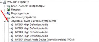
Immediately after turning on the navigator, the start page is displayed and the search for satellites begins. To determine the navigation accuracy, current altitude and coordinates, you must press and hold the antenna image in the upper left corner of the start screen for a few seconds:


The touch screen is not blocked in any way, so it is better to turn off the device while driving (the button on the back), in addition, this will save battery power. However, in the off state, navigation does not work, that is, it is extremely problematic to record your track. After turning on the navigator, the search for satellites starts again.
Setting your car navigator to pedestrian mode
There is no special mode for working with the navigator outside the car. However, you can customize a number of parameters to make the use of the auto navigator as comfortable as possible when hiking. To do this, on the start page, click on the shortcut " Settings".
Map setup
We go to the section " Map and vehicle":

Change the vehicle icon from a car to a triangle. This icon on the map indicates our location and direction:


Traditionally, the car navigation mode uses a 3D map view. In the travel version, this view is inconvenient, it is convenient to see the map from above, and choose the direction of the map " North up":


We set the parameter " Map detail"value" High", this will allow you to display the maximum number of elements on the map, although far from roads, the detail of all road maps is very low:


In section " Map layers"check the box" Trip log", all other checkboxes are also desirable to set:


Disable " Autoscale", it is absolutely unnecessary in the pedestrian mode of the navigator:


In section " My cards"the installed maps are displayed, we turn on all the maps we need. It should be noted that the Garmin Nuvi car navigators support work only with vector maps. The device is sold with pre-installed maps of Navikom CJSC." Roads of Russia. RF" or " City Navigator NT Russia"and free updates - I recommend updating the maps to the latest version. You can try to install the map" Roads of Russia. RF. Topo"- this is a topographic vector map with the coverage of the territory of the Russian Federation, this is used in Garmin tourist navigators, but this feature has not been tested. You can also try to install the OpenStreetMap map.


Here we are interested in the item " Route calculation mode"where we choose the value" Straight". This mode allows you to make a route without being tied to the road surface:


Screen setting
Moving on to the next section of settings - " Screen":

We set the optimal screen brightness. There is no need to make the screen backlight too bright, we already have enough battery for a short battery life. It is worth noting that the screen of Garmin Nuvi navigators remains readable even in bright sun.


Garmin Nuvi car navigator can automatically turn off the screen after a specified period of time if the user is not active in working with it. But it is important to note that at the moment the screen is turned off, the GPS receiver is also turned off, that is, the track cannot be recorded in this way, and after turning on with the button on the back of the device, the search for satellites is carried out again. The time until the screen turns off automatically should be selected individually, I set the value " 1 minute":


The settings made will allow you to use the Garmin Nuvi car navigator as comfortably as possible for a hiking trip.
Working with waypoints
Travel navigators not only allow you to view the map and your current location, but also save waypoints that are displayed on the map and to which you can get directions. Let's take a look at what features are inherent in the Garmin Nuvi navigators.
On the start page, click the shortcut " Where to?"in the form of a large magnifying glass and we get to the search page:

Location House
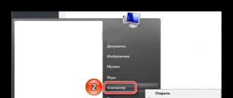
In the navigator, you can set one highlighted point for quick access - location House... To do this, press the context menu button (upper left corner of the screen), select the item " Set location Home"and in the menu that opens, select" Current location":


On the map, this point will be displayed as a house. Thus, it is convenient to set the location of your camp. And by selecting the shortcut on the search page " Home", we will get the route to this point.
Finding a point by coordinates
The coordinates of the most important points can be copied into a regular notepad, thus they will not be lost even if the navigator is inoperable. To get a route to a point with known coordinates, select the shortcut on the search page " Coordinates", enter the required coordinates in the proposed form, or select a location directly on the map:


Selecting a point on the map
You can select a point on the map by scrolling the map and tapping on the desired location. It is displayed as a blue flag. Repeated clicking on the marked point allows you to save it. Click the " Save", and the location is added to the list of saved locations:


Saving your current location
To determine the coordinates of your location and save it in the navigator's memory, click on the map on the arrow indicating your position. We get to the page " Where I am". This page displays your coordinates, height and button" Save". Press this button, enter the name of the point, press the button" Done"and the current location is added to the saved objects:


Actions on waypoints
Access to the list of waypoints is possible from the search page, if you select the item " Saved". A list of all waypoints is displayed, sorted by distance from our current location. Clicking on the line with the desired waypoint opens the action menu:


Button " i"allows you to view details for a given point - coordinates, category and distance to the point. On the page with detailed information, the context menu (button in the upper left part of the screen) allows you to delete or edit a point:


Let's take a closer look at editing a waypoint. Select the menu item " Edit":

A menu is displayed that allows you to change the name of the waypoint (entered using the virtual keyboard) and its category (entered or selected from the list presented above the virtual keyboard):


You can also change the symbol that appears on the map. The symbol is selected from the presented list of symbols:


If you select the item " Delete", you will be prompted to delete the waypoint:


To delete several waypoints at once, on the page where all saved points are displayed, select the context menu item " Remove items", then put a checkmark in front of the items to be deleted and click the" Delete". A similar deletion prompt appears:


Working with the map
To access the map on the start page, select the shortcut " Map".
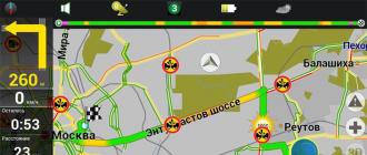
Map Panels
On the map page, in addition to the map itself, a number of information panels are displayed. By default, the right panel is hidden, to show it, enter the context menu (the button in the lower right corner of the screen) and select " Trip data":


The panel contains three fields, if you click on the field, then a list of possible values \u200b\u200bdisplayed in this field appears, thereby you can set the display of those parameters that you need at the moment. Here are some of the list items:


For the hiking option, the distance traveled, the distance to the destination, the distance to the intermediate point, the direction, the average speed in motion, the time of stops, the time in motion, the total time, the time of day, altitude, location and GPS accuracy may be useful.
Bottom right information field (in the picture above " Direction") is also configurable:

Depending on the situation, the list contains a different number of lines. If a route is laid, then additional parameters such as the distance to the destination, the distance to the intermediate point and others appear.
Bottom left information field - " Speed", is not configured in any way. But if you click on it, the trip computer opens:


There is a large number of information fields, the order of the fields does not change, the fields themselves are also not configured.
The trip computer context menu (button in the upper left corner of the screen) allows you to reset data:


Resetting the trip data resets the speed, time and distance traveled. It is convenient to do this before starting a new crossing if you want to measure your average speed, time or distance.
This is far from all that should be said about the car navigators during the hike. The article was not completed due to lack of time and fading interest in this topic.
Required!
The problem of turning a smartphone into a walking GPS navigator has been solved. The main navigator is now a smartphone, in terms of functionality and usability, it leaves far behind all existing special hiking GPS navigators. And in terms of reliability, sensitivity and battery life, he caught up with them.
I must say that the problem was solved not by me, but by the manufacturers of smartphones, batteries and software. I only selected worthy candidates and tested them in practice. I will not build secrets, I will gladly share detailed recipes, use and continue experiments.
First, about the software.
There are dozens of programs that turn a smartphone into a navigator. The choice according to my requirements left only one program: Locus Map (Locus Map). It was written only for Android, so the choice of smartphones has significantly narrowed. There is a free slightly cropped version of Locus Free, the full version of Locus PRO costs $ 6 one-time, I advise you to install it right away, because when you upgrade from Free to Pro, you will have to do all the settings anew, and there are a lot of them.
So, the main advantages of Locus, because of which it was out of competition:
- Availability of high-quality free offline vector maps of the whole world based on OSM (Open Street Maps). Here's a link to one of the. There are terabytes of regularly updated maps.
- The program understands raster maps, which are easy to make yourself from scanned paper maps. For example, using the Mapc2Mapc program. The beloved General Staff will easily take root here. Here is a present for you a map of Crimea and a Lycian path in Turkey made by me. Instructions for using Mapc2Mapc can be found below.
- Convenient recording of track and waypoints. You can draw a track manually, put waypoints anywhere, not just at your current location.
- Conveniently upload your tracks and points. Both those and others can be placed in an unlimited number of folders, enabled / disabled by folders, or separately.
- There is no limit on the number of points, tracks and points in tracks.
- The ability to turn off the auto-lock of the display (the display will still be turned off to save energy) and assign functions to the volume keys, for example, zoom. In fact, this means that the navigator can be operated without touching the screen. Relevant and when the screen is wet, it reacts incorrectly to gestures.
- Possibly location of catalogs with maps on SD-card.
- Everything is customizable: the type and size of the cursor, its position (in the center or on ¼ of the screen), the color and width of the tracks, the size of the point icons, the options for displaying the point names (constantly, opened by tap or when approaching) ...
- Unlimitedly customizable trip computers: data amount, location, font (size, transparency and color) - in any combination.
- Fine-tuning the recording of track points by time, distance and accuracy. This allows you to record only the points of real movements, and not wandering around the bush and throwing out hundreds of meters with poor communication with satellites.
- Configuring the use of the internal compass and barometer: filtering depth, on / off limits.
- Setting to turn off the GPS receiver to save power (always on, always off, only on when in use)
- Customization of all buttons of the top and two side panels, auto-hide.
- Launching the application as a service, which eliminates crashes when other applications are running at the same time (calls, photos ...). For example, for me, the recording of a track is paused when making calls, if not included as a service.
- The program is developing and constantly improving, new convenient functions appear, bugs are fixed when working on new smartphones and Android versions.
Is there more than a list? This I wrote out only what interests me. The possibilities of the program are simply prohibitive, the developers are trying to create the most universal application based on GPS. Due to the huge number of settings, it is not easy to deal with them. I will describe how to make the most needed for the hike.
This is how the program window with a vector map of Crimea looks like for me. The difference from the default is only in the buttons at the top, side and in the trip computer.
Setting up Locus.
1. Select all default directories - in the phone memory, not on an external SD card. This is done in the settings, different. Directories for vector maps locus / mapsVector and raster maps locus / maps can be placed on an external SD card, specifying this in the program settings.
2. Download a map of the area where you are so that you have something to work with.
Pre-copy vector maps (in .map format) to locus / mapsVector, and raster maps to locus / maps. If you took a vector map from the link above, then their own styles go to them, which necessarily you need to install it by going to the site with maps from your smartphone https://www.openandromaps.org/en/legend/elevate-mountain-hike-theme. In a collumn " Quick install in Android "Click Locus.Then you need to enable themes. First, activate the vector map. Then at the bottom left, pull the bookmark. there you select "external" and there will be "Elevate" and "Elements". They are exactly the same, but the first one is sharpened by default for wilderness, the second for a city. The only difference is in the checkboxes that include different elements on the map. The theme needs to be set once, suitable for all maps.
The map can be downloaded directly to smart. The maps are multilingual, the language is switched for each map separately, click three dots in the map directory to the right of the map name.
There is a big drawback for maps from openandromaps.org. The trouble is with the names of the streets in the settlements. They are either not, or displayed only on a couple of scales. But in terms of detailing the wilderness, these maps have no equal.
It happens that the program sees newly downloaded maps after restarting the smartphone.
3. Now for some important settings. The rest can be left as default.
If you don't want to get involved with long showdowns, you can just copy my settings. Download the settings file, copy it to the phone in the Locus / Backup folder (do not unpack it, just as it was downloaded, with the .zip extension), and then in the program menu select "Additional functions" -Backup Manager-Restore. Please note that in these settings the folders with maps are configured in the phone memory by default. If you want, change to an external SD card. You can also pick up my Trip Computer. This feature works only in the Pro version. Download the computer file, copy it to the Locus / data / dashboard folder. Then select it (called kravchik1) with a long tap on the computer icon (with an eye, second from the right at the top).
If you still want to figure it out on your own (due to the constant updating of the application, the settings may be in other sections and renamed):
Editing the buttons on the top and right side panels.
Entering the editor - a long tap on any element of the panel - setting the panel. Set the number of buttons on the top panel to 5, on the right panel to 2 and change the elements (remove unnecessary ones and add new functions): GPS, Data, Maps, Track Recording, Trip Computer, New Point, New Route. Moving items by clicking on the icon. “GPS” is the satellite visibility icon. Yellow - no signal, green - signal present. “Data” are directories of your tracks and points. "Maps" - entry into the catalog with maps. "Track recording" opens an additional track recording panel (it can be adjusted, I advise you to place it at the bottom). "Trip computer" turns on / off the selected computer, and with a long tap select the computer. You can draw whatever you want through the settings / additional functions / route editor. I didn't like any ready-made ones - too large characters, cover the floor of the screen. I made simple little black numbers at the top of the map, on the left. It shows speed, altitude, distance traveled. "New point" records the center of the screen as a new point, asks for the name and destination folder. New Route allows you to draw a route manually. I use this function as a distance meter.
The first five buttons will be on the top panel, the rest on the side.
The sixth, left-most element of the top panel changes differently: just a click, and a choice of several options. I advise you to choose GPS here. Will show the accuracy and the number of visible satellites. If the accuracy is displayed, say 50m, then the navigator can fool you at 300m, you should not take such readings seriously.
Control / Screen:
- "Auto-rotate lock" - check "all screens" and "portrait mode" (this will disable the auto-rotate display)
- "Disable screen lock" - put a check mark "Disable all locks" (the screen will still turn off when not in use, but it will not need to be unlocked with gestures)
Control / map screen
- hardware buttons: zoom control
Controls / panels and buttons
- left panel buttons - map style switch - check the box. This is a switch of those very themes. Different topics for different purposes
- it is better not to enable auto-hide of the top, bottom and function bar, they do not interfere if the screen is more than 4.5 inches
Track recording:
- pedestrian profile: 20m / 10s / 35m
- track recording panel view - bottom panel
GPS and sensors:
- launch at application start-always
- shutdown when inactive - I advise you to remove the daw.
- compass-autoswitching, 2 km / h
- use true track: yes
Miscellanea:
- exit confirmation: yes
- Locus as a Service: Yes
Points and Tracks:
- track line style: I advise you to choose purple color so that it does not merge with any symbols on the map, track width: 4px
Instructions for converting raster maps to Locus.sqlitedb format using Mapc2Mapc program.
Download Mapc2Mapc program, install. In the free version, the functionality is the same, but the map will be dirty with red crosses. If this is critical for you, the license costs a one-time $ 20. Or look for the broken version. I've only seen old versions, they have a lot of bugs and functionality is worse.
The program has the ability to bind a map: File / load image for calibration. But I didn’t understand this option and I bind maps in oziexplorer. How to make a separate topic binding, read the profile sites and forums.
Open the required map: File / Load calibrated map. It happens that the program finds it difficult to choose a projection. For example, for Pulkovo1942 (our favorite General Staff), you need to choose from the list, this is Russia, Georgia or Asia.
Then File / Write map for mobile device, select from the list Locus / Rmaps / Galileo .sqlitedb. Zoom and all the checkboxes can be left untouched, left by default. Click OK. Now attention! A page will open where the map is divided into squares and you can turn off any. If you click OK here, then the number of squares is increased by 4 times, so that you can choose more accurately. If you do not need to discard individual pieces of the card (or you have already thrown out), check the “No more selections” checkbox and click OK. Conversion will start. Depending on the size of the card and the performance of the computer, it can take a long time, up to several hours. Look for the converted map next to the original one.
About smartphones and improving their reliability.
Once Locus is selected, the Iphone and others automatically disappeared, only Android remained. It would be nice to use a special secure smartphone. They are not only protected from damage and water, but can also work normally in freezing temperatures down to -20. True, they are so hefty, they are reluctant to carry in everyday life. And if you do not have the means to buy a separate device for the hike, you can get by with an ordinary smartphone with water resistance. Super impact protection is useless. You need to put on the smart in silicone, stick on the protective glass and tie the device with a string to a backpack or belt. The cord is ordinary, 35-40 cm long, so that the phone does not reach the ground, and does not interfere with attaching it to the ear. If your phone does not have a lanyard eyelet, you can attach it to the silicone case.
This is how I carry mine in my backpack pocket.

Experience has shown that the minimum requirements are: 4-core 1.2 GHz processor, 2 GB of RAM, 4.5 ″ screen. It is vital that the screen can be operated properly in the rain, that is, when water droplets and fingers are wet on it. For example, Samsung S7-S10 has such screens. I am currently using S7 edge and am very satisfied.
The autonomy of the smartphone.
Ordinary devices can withstand 1.5 marching days under the following conditions: constant track recording, moderate use of the screen, constantly connected, 10 minutes of calls, 5 MB of Internet (mail, weather forecast). If you turn off the connection, it is enough for 2 days. Not much. Removable batteries are a thing of the past, now one option is to charge. The solar charging option is not suitable for active hiking. Attaching it to a backpack is inconvenient and ineffective. Normally, you can only use solar charging on vacation.
Therefore, there is only one way out: charging from a power bank on lithium-ion batteries. I have already tried about a dozen of them, of different designs. You need to choose according to the optimal combination of the main parameters: capacity, weight, price, reliability and convenience. With weight and price, everything is simple and clear. But with the most important thing - capacity, manufacturers muddy. First: absolutely everyone indicates the capacity of the internal battery for a voltage of 3.7V. But 5V comes out of the bank. Second: no one indicates the efficiency of the converter from 3.7 to 5V. And it happens from 70 to 88%. Typical 80%. So it turns out that 10000mAh is written, but in reality 5400-6400mAh. Such a power bank will charge the smartphone battery at 3600mAh from 5 to 100% 1.5 times.
Manufacturers also muddle with the charge and discharge current. Understandably, downward. The higher the charge current, the faster the power bank is charged. And the more current is given out (per discharge), the faster the phone will charge. Take power banks with fast charging, this is very important when you have a short opportunity to connect to an outlet on a hike.
From the point of view of reliability and convenience, I consider it optimal to use power banks with a "written" capacity in the region of 10000mAh. One big one is certainly more profitable in terms of price and weight. But power banks are often lost, forgotten and broken. Therefore, it is safer to take several smaller pieces.
A solar panel on a power bank is a useless weight. It takes 2 weeks to charge it!
The built-in flashlight is a dangerous thing, because it likes to accidentally turn on and wastes the charge.
I measure the capacity of the power banks with a USB tester. And it's even better not to compare the capacity, but the Watt hours. Then we move away from the need to take into account the voltage, which changes during the measurement process and an incorrect result is obtained.
Here are a few examples of tried and tested options to help you understand how different they are.
Globex 11500mAh: weight 240 gr (plastic case), real capacity 6000mah / 30Wh. It is charged with a current of 1A, gives out up to 1.5A. Full charge time 10 hours.
Drobak power roverII 10000mAh: weight 280 gr (steel body), real capacity 5400mAh / 27Wh. It charges and produces 0.85A. Full charge time 12 hours.
Xiaomi 10000mAh: weight 210g (aluminum body), real capacity 6400mAh / 32Wh. Charges 2.2A, produces 1.8A. Full charge time 5.5 hours.
Xiaomi 2 10000mAh (with fast charging): weight 222g (aluminum body), real capacity 6520mAh / 32.6Wh. Charges 2.2A / 5V, 1.5A / 9-12V, outputs 2A / 5V, 1.5A / 9-12V. Full charge time 3-5.5 hours.
Considering that Xiaomi is also not expensive, then they win in all respects! Here is a photo of the hero:

One BUT: the market is flooded with fakes of terrible quality. Look for an original thing in trusted stores with a good reputation, and in no case look at one-page sites with a discount of many%. By the way, don't buy anything on such sites! Real price of 10,000 USD 15-20
The rest of the tested power banks were collapsible, on standard 18650 batteries. Here is the best one, TOMO:


Charging separately weighs 108 grams, each battery weighs 46 grams. All together weighs 292 grams. Charges and outputs 1.8A. The money is a bit more expensive than the previous ones. TOMO has 4 independent charge / discharge channels, each battery has its own. There is a charge indicator separately for each battery. And even shows the strength of the recoil current. It is not necessary to insert all 4 batteries, it will work from one. Of course, the key here is the quality of the batteries. And I took the best ones - industrial Panasonic NCR 18650B with a real capacity of 3300-3400mAh. This is the capacity at discharge, measured with a special charger. That is, the total is 13400mAh. When discharged, 7200mAh comes out of the TOMO. Obviously, the efficiency of the converter is only 72%. Very bad. Another important nuance: in the off state, the discharge current is 0.34 mA for each battery. This means that 8% of the charge will go nowhere in a week. So you need to take out the batteries if temporarily lying around idle.
Also, I experienced similar charges, but with one charge / discharge channel, with parallel connection of batteries. Results are similar to TOMO, but performance is poor and quality is poor. During the campaign, I did not dare to hope for such people, they will fail at any moment. One plus - in the off state, there is no discharge at all.
What is the advantage of charging with 18650 batteries: you can take one charge, for 2-4 batteries, and take as many batteries as you need! Yes, even 10. It will be both cheaper and easier.
The main disadvantage was revealed in the very first campaign. Poor battery contact often. You have to wipe them, rotate them. You think that charging is in progress, but it is not really there or is weak. Such a serious drawback negates the advantages in price and weight. In addition, their efficiency is low. So I advise non-collapsible power banks.
Another application of power banks is charging batteries for cameras and camcorders. If their charging only works from 220V, it doesn't matter: on aliexpress you will find USB 5V chargers for all types of batteries.
Please note that lithium-ion batteries self-discharge by 10% per month. Therefore, be sure to recharge them before hiking.
Hunters, fishermen, tourists and even mushroom pickers have recently been increasingly using the navigator to go to the forest or go to a pond. The fact that this convenient and functional gadget will not let you get lost is understandable. But after all, it is possible to mark on it both the usual places of fish, and mushroom places, so that next year the basket and the cage do not remain empty.
There are, of course, all kinds of applications for androids, phones, smartphones, tablets and other devices, but, firstly, it is somewhat difficult to choose the best option from among them, and even if it works out, they can fail on a long hike. Phone chargers are not installed on a birch or pine tree, and at the most crucial moment your gadget may simply refuse to work. A good navigator not only holds a charge much longer, but makes it possible to quickly change the battery and generally put in ordinary batteries. In addition, all these applications will not provide such an amount of necessary and useful information as a navigator for a trip to the forest.
Types of travel navigators
Separation to the point of banality is understandable, which is good.
- Simple. Black-and-white little-functional navigators. Most of them don't even have the ability to download new maps. The maximum they can do is mark a few points and plot a couple of routes on an existing map. It is not recommended to take them on a multi-day walk, but it is quite possible to mark the mushroom spots around the dacha or the favorite sites of large bream, carp or catfish.
- Difficult. There is literally room for imagination on these devices. But this space must be approached, if not carefully, then very thoughtfully. Here you will be offered not only a large selection of maps that can be constantly updated, but also an altimeter, compass, barometer and even a pedometer. Not to mention building a route and memorizing the path already traveled. Without certain skills, you can get confused.
Depending on what exactly you want from the purchased device and you need to choose. To mark the lake so as not to come from fishing without a catch, or to stake out a small birch grove, where there are a lot of stumps - you do not need to overpay several times for this. And if you like to leave the blessings of civilization a couple of times a year and go admiring unfamiliar forest expanses or picturesque mountains for a week and a half or two, then you should shake your wallet and choose an advanced multifunctional navigator for tourism.
Navigator for fishing and hunting
This issue has already been covered somewhat above, so there is no point in repeating it. But still. Fishing and hunting are different. If you are doing these types of outdoor activities close to home, then soon you won't need a navigator either. But if you go to a new reservoir or to a completely unfamiliar forest, it is better to worry in advance that your navigator has a map of this area with all the details and an approximate route to a couple of nearby settlements.
Navigation app for android
And we managed to touch on this issue, but here it is worth deciphering a little. There are a lot of navigation applications. If someone advised you a certain thing, and you completely trust the advisor, you should still drive such a navigator a little, after downloading it to your android and always before going into the forest. In most cases, additional, but very useful functions are absent in the initial version, and they will have to be downloaded and installed separately, often for an additional fee. And most importantly, do not forget to make sure that the battery of the gadget is 100% charged before going into the forest.

Navigator for iPhone
This option will be better than android. Firstly, because a good application has updates online, and you will always know where you are. Secondly, the functionality of such applications is much better, and the connection, if the satellite is connected, is many times better.
Navigator Garmin
The most affordable model of navigators among hunters, tourists, fishermen, mushroom pickers and simply amateurs going on a hike. However, the cheapness this time does not mean the lack of quality. The device meets almost all requests. Small in size, which makes it easy to handle with one hand without connecting the other. The case is durable, waterproof and non-slippery. The joystick is convenient even for working with gloves and has a locking function, which is very convenient in order not to accidentally confuse the route or other indicators. The battery is designed for uninterrupted operation for 20-24 hours. The device is equipped with all sorts of useful functions and add-ons. In the search for mushrooms, fish or the desired path, this is a very good helper.

An absolutely necessary device in the car, it is absolutely useless to argue with this. It will show you exactly how to get to the forest and from that moment you can safely turn it off. It is impossible to navigate in the forest using a car navigator. And not only because the car will not pass there, it will squeeze through in some places. And because he is not programmed for this. It is usually loaded with a map of streets, squares, lanes and suburban highways. They can advise where it is better to go around the traffic jam. Forests and the surface of the lake are indicated by a solid blue or green spot on car navigators, and for a mushroom picker or fisherman they are just like “white spots”.

How to choose a hiking navigator
Before you go to a specialized store, and in the store itself, you need to pay attention to some parameters of the selected device.
Physical parameters
The size and weight of the navigator plays an important role if you have a long walk on rough terrain ahead. Of course, he will not pull his arms or shoulders, but the ideal option would be a device that fits in the palm of your hand and fits into the most convenient pocket, from where you can easily get it at any time without slowing down. There is no need to remind that it should be well protected from moisture, dirt, dust and other troubles.
Display
The color display is not only beautiful, but also much more practical in terms of reading and understanding the displayed information. However, there are two rather significant disadvantages here. Such a screen consumes a lot more energy, which means that you have to worry about additional batteries. On a sunny day, you will either have to look for a shaded corner or cover the screen with your hands, since the contrast can play a very unpleasant joke. The disadvantages are not so significant, but anyway, if you plan to use the navigator not on long hiking trips, it is quite possible to get by with a black and white display.
CPU
For avid tourists, who have multi-day hikes ahead, the question of processor power is not worth it. The more powerful the better, there is nothing to argue about. Standing in one place and waiting for the navigator to process information on such trips is not only boring, but you can also get out of the schedule.
Memory size
The same principle applies here as with processor power. The more memory, the more maps can be loaded into the navigator. The ideal option would be a device that allows you to use additional media such as micro SD. Well, the minimum memory size should be 1 GB.
Charging
This is one of the first questions a seller is asked when choosing a travel navigator. And again, the principle should be: the more the better. A device whose passport states that it lasts less than 15 hours should not even be considered. On a long hike, you will have to change the batteries more than once or twice, but drag them with you, and to the city, because throwing out charging cells in the forest is to harm nature, it is not very pleasant.
Cartographic capabilities
In addition to the fact that the navigator shows you your location in a certain area of \u200b\u200bthe terrain, it is also good that it allows you to update the maps loaded into it. This will help to reduce the error of indicators and will enable the user to make the necessary adjustments.
Case and cover
A cover is desirable. Especially if during the trip the river crossing is planned, during which the opportunity to wet the luggage increases significantly. And the navigator is also not insured against falling from a height or on an untimely turned up stone. Even a high-quality housing of the device itself may not withstand the overloads of a difficult tourist route, so extra protection will not hurt.
The requirements for the body itself were described above, but it is worth repeating them:
- Strength.
- Tightness.
- The presence of softening and anti-slip elements.
We can safely say that in some conditions you will appreciate your prudence.
It is better to go on a multi-day hiking trip with an experienced guide, or a person who has been to these places more than once and knows some signs and relief features that allow you to quickly determine the location of the group and correct the route in case of deviation from the planned paths.
However, a good travel navigator can help out too. The main thing when buying is to adhere to the parameters and requirements listed above and, before going on a trip, thoroughly study all the capabilities of the device, load all the necessary applications and functions into it and exercise a little in familiar terrain. And then your journey will not be overshadowed by an unexpected unfamiliar landscape, which, instead of striking with its beauty, will frighten you with the realization that you are lost.