Navigator "Navitel" - software designed for finding the shortest routes on the map. Thanks to the "voice prompt" function, the driver can control the car without being distracted by the navigator screen. You can quickly learn to use the Navitel navigator.
Fast navigation through the article
Navigator tasks
The main tasks of the navigator are:
- Manual and automatic routing;
- Positioning and displaying on the map;
- Search for objects;
- Calculation of travel information and displaying it on the map. Possibility of recording and displaying the route of movement in the form of a track and more.
Advantages of the Navitel navigator
This program compares favorably with analogues and has a number of advantages:
- Implemented fast scrolling of maps and zooming;
- You can choose the orientation of the map: in the directions of movement, route or north;
- Allows you to automatically switch between maps;
- Has a full screen mode;
- Fully supports 2D and pseudo 3D;
- Loads up-to-date traffic information (provided by Navitel);
- Has tooltips.
Practice of use
To learn how to use the Navitel navigator as quickly as possible, it is enough to practice determining your location and plot a route:
- We open "Navitel". If the program is installed on the phone, then before opening it, you must activate GPS. Everything is on by default on the navigator.
- A message will appear on the screen: "To update traffic jams, you need to connect to the Internet, allow?" and 3 possible answers: "always allow", "allow" and "deny". We choose the necessary one.
- After a positive answer to the previous question, the Navitel program is open and the maps are loaded. Next, you need to enable (find) satellites. To do this, you need to click on the green "satellite dish" icon. (If there is a yellow circle on this icon, then the program has not found satellites yet). After clicking, a menu opens with the following options: "turn off GPS", "satellites", "settings" and "cancel". We select "satellites".
- The program communicates with satellites for a couple of seconds. It should be remembered that Navitel can plot a route only with at least 4 satellites found. If you are in a building, Navitel may not see such a number of satellites (this usually does not cause problems in the car and in the open space).
- After the navigator "Navitel" has found the required number of satellites, press the "back" button (which returns you to the main page).
Now the program automatically detects your location - half the battle is done. Let's move on to the next step - let's start plotting the route.
Making a route
Open the navigator menu "Navitel" (or program). At the bottom right, click "menu". Then the following options pop up:
- By the address;
- Nearest on the map;
- Waypoints;
- History;
- Favorite;
- By coordinates;
- Navitel SMS.
You need to choose "by address". As a result, your location is determined at this moment.
Next, you need to select the street and house number (where you want to go). If the program does not find such a house, then you can enter another nearest house (and you will find your way around the place). If the route is laid to another city or country, then fill in the appropriate information in the first and second columns.
All! You can follow the paved route on foot, by bike or by car.
Route correction
If the navigator "Navitel" has laid the route not as it should be, or you need to call in a place that is not included in the laid route. Then we do the following:
- We move the map to the place where you need to call along the way. For example, to a city (let it be city X), which did not fall into your route. Move the map to town X.
- We increase the scale of the map and poke the city with the stylus (finger). Save the point. At this stage, you can name the point or leave the default "001". We give the name to our point "city X".
- Next, we press the button "find", then "waypoints". Here we find and select "city X". After that, the menu automatically appears or the "Show on the map" button immediately appears (depending on the version of the program). Click on it. The map with the point "city X" opens.
- At the top of the screen we find and click "call in".
Done! The program will automatically re-map your route taking into account your city X. After each correction of the route, you must save it by clicking on "export".
Useful little things
To make the use of the Navitel navigator as enjoyable as possible, you can make your own settings. To do this, go to the "menu" (located at the bottom right) and select "settings" in which 6 items appear. Let's consider three main ones:
Map rotation
Press the first tab "map", then "up map". There are two options for displaying the map: "north up" and "rotate by movement". The best option is "rotate on the move": the map on the display will be displayed in the direction of your movement.
Navigation settings
Second tab "Navigation":
- Press the "mode of transport" and select the required one (which will optimize the work of the program);
- We press "route". Next comes the choice of "on the road" or "in a straight line", as well as "fast" or "short". Choosing the options you need;
- We press "lead". Here you can set the "maneuver warning" (early and before the maneuver) and "off-track sensitivity" (low and high).
Additional settings
Click the "device" tab. Here you can set "power", "sound" and "clock".
At this stage, you can finish with the basic settings, which will be quite enough for new users of the Navitel navigator. Now you cannot be forced to use paper maps for navigation.
Traveling with modern navigators is a pleasure. There is no need to navigate on paper maps, understand what azimuth is, or learn how to use a compass. There is no need to navigate by the stars or look at the trees, figuring out which side the moss grows, and where in this forest to find the north ...
It is enough to enter the coordinates or load the track into the navigator, and the automatics will not only plot the route, but also tell by voice prompts which direction you need to turn and how much more you need to drive or walk.
But even modern navigators need to learn how to use, otherwise this "electronic toy" will remain in your pocket idle.
The choice of navigators and programs - applications for orientation and travel is very large. Let's dwell on one of the main ones, most often used by tourists - Navitel software. By the way, in recent years we have been traveling with the Navitel navigator in Russia, and in neighboring countries, and in Europe, having previously loaded the maps we need for travel.
Brief description of Navitel software
In my opinion, the most convenient and frequently used software by autotourists. A small survey conducted on our website Auto Tramp confirmed the leadership of this program among auto tourists.
The program does not need a permanent Internet connection, is absolutely mobile, and has completely up-to-date road maps - from federal highways to country and field roads.
In the "Navigator" you can not only plot a route by specifying a specific address of an object, but also plot a route using GPS coordinates and even load GPS tracks.
The Navitel program is not only easily loaded into many road (car) computers and road navigators, but also perfectly loaded into tablets and smartphones.
The program can be downloaded from the Play Store, there are both free and paid versions.
Basic settings that may be useful to us
Regardless of the device in which you have installed Navitel software, its use and routing is the same everywhere.
Before you start laying the route, you need to set the program settings, which will determine which road the navigator will take (asphalt, grader, forest road, as well as the presence of toll roads and water crossings along the way).
I will not go into detail about all the functions of the program, I will focus only on the most necessary for travel.

Despite the excellent convenience of traveling with Navitel, do not forget to look at the road signs while traveling.
There are situations when outdated road maps are loaded in the program, and the navigator will take you not quite where you wanted. This is especially true for grader roads or roads that have not been used for a long time. For example, if a bridge has been washed away on the river and instead of restoring the old bridge, it is easier to build a new one a few kilometers from the old one.
Laying the city route
Suppose we are planning to go to the city of Tobolsk.

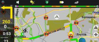
To the left of the paved route, you will see the distance to the object, and some directions: how much to turn, how much left to drive, as well as your current speed and time required to travel.
Laying an off-road route using GPS coordinates
Traveling on public roads and city attractions with the help of the navigator is easy. Actually, laying a route using GPS coordinates is also not difficult.
On our site, a coordinate system is used that assumes the establishment of coordinates in the following form: N 56º25,849´; E 60º30.503 '(these are the coordinates of the Markov Kamen mountain in the Sverdlovsk region).
- First, we change the settings in the navigator. To do this, go to "Main Menu" - "Settings" - "Tracks".
- In the "Tracks" tab that opens, turn on "GPX format (* .gpx)".

- If necessary, turn on "Track Recording" and remember where the tracks will be recorded later.
- Then you need to return to "Main Menu" - "Route" - "Create Route" - "Waypoints".
- In the "Waypoints" tab, on the informative line below, press the "Add point" button.
- In the opened Waypoint tab, carefully fill in the necessary coordinates. After entering the coordinates, you must click the "Jackdaw" in the upper right corner. Pressing it will return you to the "Waypoint" tab with the entered coordinates. Next, you need to enter the name of the point, or just leave its default number.


- A little tip: always try to give the points unique names, otherwise after a while you will not be able to remember what the point is in your navigator, and why you put it.
- Press the checkbox in the upper right corner again, and you will find yourself in the list of "Waypoints", in which you, if everything is done correctly, will see the waypoint you just entered.
- Click on the point you entered and a map with the saved point will open to you. When you click on the "Let's go" button in the bottom information line, the program will generate a trip route.


- You can add the required number of points by repeating the above process several times.
Please note the following. If Navitel navigator does not see any road or grader or forest road, which is available in the program database, to the required point, it will simply lay a straight line from your current location to the point. As a rule, straight lines indicate the need to walk this part of the path.
Fill someone else's track in Navitel
Traveling along routes laid out by an address or by coordinates - this is not all the functionality included in the program. The Navitel program also assumes the ability to download other people's tracks, that is, tracks recorded on other devices and other tourists.
The program supports several types of track extensions, in particular, one of the most popular, and also actively used by us (on our website site) tracks in the .plt format.
There are two main ways to download tracks.
We copy the required track from the computer to the navigator
Copy the required track from the computer to the program folder: NavitelContent / Download. And from this folder we load it into routes.
- We go to "Main menu" - "Route" - "Import".
- In the left submenu, select the required folder and the required file.
- Click on the selected file.
- The "Import" menu will open, in it you need to select the entire list of tracks. Just put the cursor on the "all tracks" position, and click the checkmark in the upper right corner.
- If everything is done correctly, you will see a map with a loaded track. On the left you will see information about the distance and estimated travel time.


This method is suitable for downloading to both navigators and tablets and smartphones.
Download the track via the Internet and upload it to the program
If it is not possible to download from a computer, for example, if you are on the road, but you have a working Internet at hand, you can also download the track from the website. Many sites, like us, archive tracks in the program - archiver WinRAR or similar. This allows you to both reduce the volume of the track and simplify its downloading via the Internet.
To download and install archived tracks, you must have an archiver program on your tablet computer or smartphone. It can be easily downloaded from the Play Store.
P.S. I will repeat myself. In different versions of the program, and accordingly, in different navigators in which the Navitel program is installed, the structure and type of the main menus may slightly differ. But the essence remains the same.
Navitel - the leading paid digital satellite navigation software to illustrate traffic on established routes. Navitel was released by the Russian company "Center for Navigation Technologies" and has achieved great success, collecting a lot of positive feedback from users, especially on the latest versions of the program, which have significantly improved their quality. The program is available for communicators based on iOS, Windows Mobile, Windows Phone, Java, Bada, Android, etc., as well as for PDAs.
Using the program and getting directions to Navitel is not particularly difficult
- At first turn on GPS (if you use a phone, everything will already be turned on in the navigator).
- We launch Navitel itself.
- When it turns on and loads the map, it may not be showing where you really are.
- Then, to make the display more correct, need to catch satellites.
- Select the green satellite dish icon (if the icon is yellow, it means that the program has not yet connected to satellites).
- A menu will open, choose " satellites«.
- In the window that appears, satellites will be shown, some of them are in search, some are still showing up. Determined satellites will light up green.

Keep in mind that Navitel catches only in open areas, which means that if you are indoors and there is at least one floor above you, satellites most likely will not be found! In the car, however, this is not a problem - there is no floor above.
Press the "Back" button and return to the main page - using the satellites, the location should be determined correctly. Now you can start building a route in Navitel.
How to create a route in Navitel from city to city
First, let's see how to get a route directly from city to city (or just from one place to another). This can be either the place where you are now (then the route is laid to the destination), or any other. One way or another, initially we need two points.
- Maximum zoom in and point a finger to the starting point.
- We press the button " Save"And save the waypoint, give it a name -" Start«.
- Now we scroll the map to the final destination and do the same, give the name to the second point "Finish".
- Scroll back to the starting point " Start“, We want it to be exactly in the middle of the screen.
- Click " To find“, Indicate that you need to search for Waypoints. We find "Finish". Select by poking your finger (stylus).
- A button or menu item will appear (depending on the version of your Navitel) " To show on the map«.
- We poke. We will see the finish point, that is, the destination, and click at the top of the screen “ To go«.
A route will be laid from one point to another. But it is not a fact that it will be optimal, so the option with several points is preferable.
How to make a route in Navitel with several points
We are not in a hurry to delete our route! Let's save it (first, "Menu", then "Route", then "Route properties"). Click on the button depicting the list below. We select the menu item "Export". We save the file, for example, under the name "Our first route".
Now close Navitel completely and launch it again. When asked whether to continue the previously laid route - we refuse!
- Go to the Menu, then “ Route", Then" Route properties«;
- Press the button representing the list;
- Menu item " Import«;
- We find " Our first route"And select it again - it will open.
Now we will use intermediate points to correct the route.... Let's say we know that the best way for us is from " Start"To" Finish"Will pass through the road that Navitel ignored.
- We then look for this road and put a point on it, say, “ Road“, We save it;
- Now again in " To find“, We are looking for waypoints, we select our point“ Road ”;
- Then “ To show on the map«;
- A map with a dot " Road"And now press the button" Stop by«!
All! The route will be laid so that the path from "Start" to "Finish" will pass through the "Road". And if, in addition to the road, you need the "Ravine", and the "Store", and other points, then it's not a problem to put them in the same way! As you can see, everything is very simple - enjoy your navigation!
If you are unable to do something on your own, then we advise you to contact an ambulance computer help - pchelp24.com, reasonable prices, experienced specialists, free call and diagnostics.
Navitel is the leading paid digital satellite navigation software for illustrating traffic on paved routes. Navitel was released by the Russian company "Center for Navigation Technologies" and achieved great success, collecting a lot of positive feedback from users, especially on the latest versions of the program, which have significantly improved their quality. The program is available for communicators based on iOS, Windows Mobile, Windows Phone, Java, Bada, Android, etc., as well as for PDAs.
Using the program and getting directions to Navitel is not particularly difficult. First, turn on the GPS (if you use a phone, everything will already be turned on in the navigator). We launch Navitel itself. When it turns on and loads the map, it may not be showing where you really are. Then, for the display to be more correct, you need to catch the satellites. Select the green satellite dish icon (if the icon is yellow, it means that the program has not yet connected to the satellites). A menu will open, select "satellites". In the window that appears, satellites will be shown, some of them are in search, some are still showing up. The determined satellites will light up green.
Keep in mind that Navitel catches only in open areas, which means that if you are indoors and there is at least one floor above you, satellites most likely will not be found! In the car, however, this is not a problem - there is no floor above.
Press the "Back" button and return to the main page - with the help of satellites, the location should be determined correctly. Now you can start building a route in Navitel.
How to create a route in Navitel from city to city
First, let's see how to get a route directly from city to city (or just from one place to another). This can be either the place where you are now (then the route is laid to the destination), or any other. One way or another, initially we need two points.
Increase the scale as much as possible and poke your finger at the starting point. We press the "Save" button and save the waypoint, give a name for it - "Start". Now we scroll the map to the final destination and do the same, name the second point "Finish". Scroll back to the starting point "Start", make sure that it is exactly in the middle of the screen. Press "Find", indicate that you need to search for Waypoints. We find "Finish". Select by poking your finger (stylus). A button or menu item (depending on the version of your Navitel) "Show on map" will appear. We poke. We will see the finish point, that is, the destination, and click "Go" at the top of the screen.
A route will be laid from one point to another. But it is not a fact that it will be optimal, so the option with several points is preferable.
How to make a route in Navitel with several points
We are not in a hurry to delete our route! Let's save it (first, "Menu", then "Route", then "Route Properties"). Click on the button depicting the list below. Select the menu item "Export". We save the file, for example, under the name "Our first route".
Now close Navitel completely and launch it again. When asked whether to continue the previously laid route - we refuse!
Now we will use intermediate points to correct the route. Let's say we know that the best way for us from "Start" to "Finish" will be across the road that Navitel ignored.
We then look for this road and put a point on it, say, "Road", save it; Now again in "Find", we are looking for waypoints, select our point "Road"; Then "Show on map"; The map with the "Road" point will open and now press the "Enter" button!
All! The route will be laid so that the path from "Start" to "Finish" will pass through the "Road". And if, in addition to the road, you need the "Ravine", and the "Shop", and other points, then it's not a problem to put them in the same way! As you can see, everything is very simple - enjoy your navigation!
(adsbygoogle \u003d window.adsbygoogle ||) .push (());
Yandex Navigator is a great app, the brainchild of the search giant Yandex. It was released a few years ago quite raw, and as a result received a huge amount of not very positive reviews. At the moment, many errors have been fixed and the number of downloads, as well as users, is growing rapidly, only from Google Play there are already more than 10 million downloads.
From this short post, you will understand:
- How to download, install and use the free Yandex Navigator application.
- You can figure out how to solve this or that problem.
- Check out consumer reviews of the product.
The navigator can be installed on:
- Android;
- iPhone;
- Windows Phone.
To install the latest version of the navigator, the easiest way is to go to the official website page or directly to the application loader of your smartphone or tablet.
For example, I'll show you how to install Yandex Navigator on Android:
First you need to visit Google Play using the link above and click on the "Install" button, accept the terms of the application and wait for the download to finish.


After the download is complete, the application will be installed on the smartphone. At the end, the "Open" button will appear, click on it. White background presentation of Yandex Navigator, then I was immediately offered the voice acting of "Vasily Utkin", you can turn it on or click on the cross above.


This completes the installation of Yandex Navigator, you can start getting acquainted and setting up.
Yandex navigator user manual
How to enter coordinates in Yandex navigator
If you know the coordinates of your final destination, you can type them into the search for how to do this. It's easier to do this on a computer, copy the coordinates and paste, on a smartphone, in principle, you can also do this, although let me show you several options at once on how to enter coordinates into Yandex navigator:
- The first time I found the coordinates I needed and sent them to myself from my computer via a message via Vkontakte. Then I went to VK from my smartphone and copied the coordinates. Then I inserted them into the search line in the navigator, everything works fine, the place was determined instantly.
- The same can be done via SMS.
- Then I started looking for these top zeros and quotation marks on the keyboard and digging around a bit, I found them. I had this top zero (degree sign) in the symbols "? 1 :-)", and from there you still need to go to "\u003d \\<«, на вашей клавиатуре может быть по другому, полазьте обязательно найдете этот злосчастный символ.
- You can copy from this page and paste it into your navigator, just change the numbers - 38 ° 52′31 ″ E 56 ° 28′7 ″ N
Let me remind you that coordinates in Yandex navigator are entered into the search line:

Get directions from the current point
To build a route from the current point in the Yandex navigator, you need to find this point on the map:
- through voice search;
- register the name (city, address);
- find on the map yourself;
- select from saved points.
After you have chosen the end point, you need to click "Let's go".
Build a route between two specified points
In order to build a route between two points, you must first select the end point and click "Here", then find the starting point and click "From Here".


Everything is quite simple, after the route is set and one of the proposed options is selected, press "Let's go". You can also select the points of departure and arrival from the saved places.
How to clarify the route and set intermediate points
To select a route option or set intermediate points, you need to select a point on the map and select the "Through" button in the context menu.
As in the previous options for creating a route, you can select an intermediate point from previously saved locations.
How to save a route or point on the map to My Places
Download offline maps for Yandex Navigator
In order to spend less traffic and to load the map faster along the route, it is better to have a downloaded map of the city or area of \u200b\u200bmovement you need.
In order to download maps you need:
- Go to the "Menu".
- Enter a city in the search.
- Download and wait for unpacking.
After unpacking, the maps will be available offline, without the Internet. There are a few things worth noting:
- Maps take up a lot of space, for example, a map of Moscow and the Moscow region takes up more than 400 MB, so it's better to use free Internet or WiFi for downloading.
- In offline mode, without an Internet connection and the GPS navigator will not be able to determine your location, the map will work correctly, and it will not be so difficult for someone who can read maps to figure it out.
- The downloaded map will significantly reduce the amount of traffic consumed and speed up the work with the navigator.
Voices for Yandex Navigator
At the moment, Yandex Navigator accommodates 3 voices in its assembly:
- Dima;
- Oksana;
- Vasily Utkin.
In the same Sounds menu, you can change other settings:
- Tongue;
- warn about events;
- excess message;
- enable / disable voice guidance;
- voice activation.
Answers to frequently asked questions
I tried to put together questions and solutions to problems arising with Yandex Navigator, if you did not find the answer to your question, you can ask your question in the comments. Well, let's get started.
- Does Yandex navigator work without the Internet? The answer is yes, it works, but partially. If you have downloaded the maps you need, you can safely browse them, search for places and study the road. Without internet it is not possible to get directions.
- How to update Yandex navigator? In order to update your navigator, you need to go to Google play or Apstor and in the tab my applications see if there are updates for the navigator.
- What to do if the Yandex navigator does not follow the route? Check if you have GPS turned on, if you have an active Internet connection, check the speed of the Internet (climb the sites, whether the pages are loading quickly), restart the navigator, restart the phone, uninstall and install over again. If all else fails, delete and forget about this navigator, it does not suit you or your smartphone. For some, everything works fine, for others, nothing works, take it easy. 😉 If the problem occurs after the update or suddenly, most likely you can fix it if you dig deeper right after installation, if not, look for another option.
- Yandex navigator not working? Do the same as in step 4! This is a panacea for all ills.
- When yandex navigator does not show an arrow or does not find a location or shows the letter "I" check if GPS and Internet are turned on, if there is no point 4 to help you.
- Yandex navigator does not plot a route without the Internet, and at the moment you need to come to terms with this! Perhaps in the future, this will be corrected, while I can only recommend item 4 of this list.
- Why doesn't Yandex navigator speak? Most likely, he is arrogant and does not consider you a useful interlocutor (just kidding), or you turned off the sound in the application, or perhaps turned it off in the settings menu.
Yandex navigator user reviews
I read a huge number of reviews on all kinds of sites, in this block of the article I will summarize everything that was said by users in 2016, I did not take into account the reviews for 2014, since the Yandex Navigator application has undergone a lot of changes and improvements during this time.
Cons (disadvantages) Yandex Navigator
- Without an Internet connection, you can only work with the map, it is impossible to plan a route and learn about traffic jams.
- Sometimes it shows the wrong distance (in meters).
- Tupit, errors take off, etc.
I won't even enumerate everything, there are many people and many opinions, I want to note the following - for normal operation with Yandex navigator, you need a normal Internet, an acceptable smartphone, an adequate driver.
Considering the fact that Yandex navigator has already been downloaded tens of millions of times, and reviews are mostly left by those who are looking for solutions to certain problems, then we can draw one conclusion: “Download and try if this application is right for you and for your city or not".
Testing will not take much time, but the result will answer for itself.
Pros (advantages) of Yandex Navigator
- Completely free;
- cards are also "on the ball";
- does not require additional devices (there is a smartphone, why buy also a GPS);
- adequate, reacts to an intelligible voice, warns normally, has an updated map of traffic jams, etc.
Our people, accustomed to receiving everything for free, and even demanding excellent quality, are just okay. The program is good, it understands the user, it hangs only on crooked or poorly configured phones.