The Google Satellite interactive map is a free service from the well-known Google corporation.
The service provides access to verified cartographic information from almost any region of the planet, including the location and purpose of objects.
In this case, the display occurs in several modes and without advertisements and other unnecessary data.
Google created the service using satellite views and collected photographs of the Earth's surface.
The result is a service like Google Earth - without some features, but working online.
Working with the map
When working with Google Maps, there are several options for presenting information:
- In the usual form, reminiscent of an automobile atlas, with the names of settlements, streets and other objects;
- A satellite map shown not in real time, but in the form of photos from space taken some time ago (images are constantly updated). In this case, street names, house numbers and other information from the map are superimposed on top of the images.

Switching modes is done using the icon in the lower left corner of the map.
Previously, there were three modes, including a regular satellite photo without captions, but the service abandoned the last option, combining it with a regular map.
Although names can still be disabled by selecting “Hide names” in the service menu.

The scale of the maps is based on the Mercator projection and remains constant. This means that as you approach the equator, the distances between the meridians increase.
Linking to the Google Maps globe is carried out using a similar service - Google Earth.
Detailed maps exist only for large populated areas.
For suburban areas and, especially, uninhabited areas, there are practically no clear photographs, and the resolution of the photographs is lower. Sometimes the area is hidden by clouds or their shadows.
Interface Features
The service works using search queries. The entered keyword is compared with the markers on the map, and if a match is found, an image of the found location is displayed on the screen.

At the same time, in addition to the map, the weather forecast is shown, and the opportunity to view photos and panoramic images of the surrounding area (if available) is provided.
The picture switches to atlas mode in the same way.
A route planning service can also be useful, thanks to which you can find out:
- What routes can you take to get to the specified place?
- Distance from one point to another;
- Travel time by personal and public transport;
- Numbers of buses or metro stations that can be used to travel the required distance.

Using the navigation panel, you can adjust the high quality and accuracy of the image. And right while using any other function of the service.

If necessary, the image can be shown in a different projection - side view. And the routes are chosen using not only vehicles, but also bicycles.
Information about moving from one point to another on foot is also available.

Possibilities
Among the additional features of the service is the ability to view the chronology of your movements - unless, of course, the application is built into the desktop browser, but is installed on a mobile gadget or laptop.
In this case, Google maps will allow you to view all visits since the installation of the program.

In addition, for a mobile gadget, the Google Maps service provides the ability to download offline maps of Russia or another country.
Thus, even if you find yourself without a connection, but with a smartphone or tablet, you can use map data, although without reference to the area.
All this is available for both iOS and Android devices.
If you still have the Internet, you can see online not only routes and objects, but also see, for example, where the nearest gas station is and even the price of fuel.
A traffic jam search function is available for populated areas. It even provides details such as traffic density and possible detour routes.
Advice! The option will be useful for traveling to and from work, and when planning an out-of-town trip.

Features of the service
Google maps don't have all the information. Some countries have not allowed satellite images to be taken and stored in some areas where sensitive facilities are located.
Such territories are indicated by shading. And these include, for example, military bases, the Capitol and the White House.

Some of the images were taken not from space, but from a height of 300 m. Therefore, in some points the world map may be more detailed than elsewhere.
The same applies to panoramic images - on some streets covered by the area survey program they are available, on others you can only see a satellite image and a map.
- Yandex news, translator, money, cards - complete stuffing
Service development
The Google service, which displays land and other objects online, began operating in 2005.
Although at first there were no satellite maps, by 2006 the service not only spread throughout the planet, but also became available as an application for smartphones.
The following year, an improved version of Google Maps was released with location reference using a GPS module.
And after some time, the program was offered for mobile devices running on Windows, BlackBerry OS, Android and iOS.

In 2017, the number of service users exceeded 1 billion people.
Google maps. Travel without leaving home
In this video you will see how to use google maps.
Many users would like to enjoy satellite photos of their native places, to see their house, a nearby river or forest from above, in a word, everything that is commonly called “small Motherland”. A tool for realizing this desire can be satellite mapping services, which provide a unique opportunity to view all required geolocations in detailed graphic mode. After my attempts to look at my home online from a satellite, I found really high-quality services and in this article I will share my experiences.
There is a huge variety of mapping services on the Internet that provide the user with access to high-resolution satellite maps. At the same time, the vast majority of such services use the API from Google Maps, and only a few services (including the domestic Yandex.Maps) can boast of their own cartographic developments that differ from the dominant Google maps in this segment.
At the same time, working with such cards is quite formulaic. You go to one of them, turn on satellite display if necessary, and then enter your address (town, street, house number) into the search bar. After this, the service finds the required location, and you can use the mouse wheel to increase or decrease the existing display. If for some reason the service does not find your house, I recommend entering the name of the city (town, village) and street, and then find the desired house yourself using the mouse.

At the same time, some services allow you not only to see your house from above, but also to walk along the streets of your hometown and enjoy the view of the buildings we need up close.
Let's move on to the list of services that will help us see our home from satellite.
Google Maps - look at your home from satellite in real time
The most popular global mapping resource is undoubtedly Google Maps. In addition to maps presented in schematic and satellite form, the service also includes the ability to 360° view the streets of many cities around the world (Street View). Information about street traffic and traffic jams (Google Traffic), a route planner from point A to point B, 3D display of many geographical points, and other useful features.
There are two main options to view your home:

Yandex.Maps - will allow you to see the necessary object in Russia
Another mapping service with which you can enjoy the view of your home is Yandex.Maps. This service is the most popular in Russia, since the level of display of the territory of Russia and the frequency of updating data for the Russian Federation exceeds all existing analogues, including generally accepted maps from Google.
Like the Google Maps service, Yandex.Maps can boast of both standard and satellite display of maps (as well as the “Hybrid” mode, which involves applying various text and schematic markings on a satellite map). In addition, users have access to a street display mode (“Yandex.Panoramas”), a traffic congestion indicator (“Yandex.Traffic”), as well as the “People’s Map” crowdsourcing system, which can be edited by any user.

To view your home using Yandex.Maps, go to the resource, enter your address in the search bar at the top, and press enter. To switch to street view mode, click on the button with binoculars at the bottom of the screen (street panoramas and photographs). And then select one of the streets marked in blue (you will switch to the street view mode at this point, and you will be able to enjoy the color of these places).
Bing.Maps – satellite map from Microsoft
Bing.Maps is an online mapping service from Microsoft, formerly known as Windows Live Maps and MSN Virtual Earth. Its capabilities include satellite display of maps, street view, 3D display for 60 cities around the world, plotting the optimal route and other features that are standard for services of this type.

To watch your home using Bing.Maps, go to the specified service, click on “Road” on the right, and select “Hybrid View”. Then enter the address you need into the search bar and view the view that opens.
MapQuest is a popular American mapping service
"MapQuest" (translated as “Card Search”) is a free American mapping service, the second most popular in the United States after Google Maps. The resource boasts a high degree of detail on the streets of many countries around the world, will help you plot a convenient route, inform you about existing traffic, and much more.
To work with it, you need to go to this resource, click on the button with the image of the globe on the right (Satelite), which will allow you to switch to satellite display mode. After that, in the search bar on the left, enter the address you need (preferably in Latin), and enjoy displaying the desired location using the MapQuest service.
 MapQuest is the second most popular service in the United States
 Conclusion
You can view your home from satellite using the services I listed in this material. For the territory of Russia, I would recommend the Yandex.Maps service - the level of detail and frequency of updated data inspires us to consider maps from Yandex the best mapping service in the Russian Federation. On a global scale, the Google Maps service is the undisputed leader, so it would be optimal to use the tools of this service to display maps of many countries around the world.
In contact with
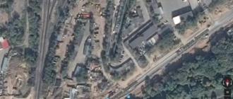
Satellite map of Russia - high-resolution images taken from space by orbital stations. The image that the user sees consists of many individual images. The high quality of equipment used at orbital stations made it possible to achieve the highest quality of imaging. As a result, on the screens of mobile devices and PC monitors, we have access to high-precision, high-resolution images, the image of which is very accurate and clear.
The satellite map of Russia displays high-resolution images in real time. You can see almost all Russian cities on them. By zooming in and out of objects, moving the cursor over individual sections of the map, you will be able to view streets, buildings, individual structures and squares. The larger the city, the more detailed the satellite map section will be for it.
Satellite map online in real time 2016 - exploring the country together
High resolution satellite maps online 2016 - a set of high-precision images through which you can study settlements of different sizes at a specific point in time. The user, selecting the object and scale he needs, receives a snapshot of it at the same point in time. By selecting the appropriate parameters instead of the “satellite view” mode, you can display the image:
- landscape view;
- schematic representation of Russia and its individual cities;
- Satellite view - real image.
Online high-resolution satellite maps of 2015-2016 are the most user-friendly models of interactive map images from the website service. They will allow you to travel throughout the entire state, from anywhere in the world. Satellites make it possible to track current data on the location and condition of various muddy objects from different settlements in vast Russia.
Google Map is one of the most popular services today. It provides users with the opportunity to observe our planet (and not only) from a satellite online in high quality and in real time (sights of the planet in). At some point, the primacy of the schematic map view was captured by the Open Street Maps application. Where everyone in the know can edit a map in Wikipedia style, but this does not change anything and today Google Maps is the most popular online map service. The popularity of this company's maps has been in first place for many years due to the good quality of satellite images in every corner of the planet; even Yandex could not provide such quality in its homeland.
Google Maps online
Google continues to improve its brainchild in the form of visualization of our planet, improving the quality and detail of surfaces. More recently, the company has improved its services using the new Landsat 8 satellite, which can photograph the surface of planet Earth with a resolution of 15/30/100 meters per elemental point. The database of satellite images in real time was previously updated only in 2013. At that time, the application used images taken by the Landsat 7 satellite, which was also known for introducing some bugs and glitches into the maps. To compare the quality of images taken by different satellites, pay attention to the screenshot below.

Images taken by different satellites
In the examples given on the screen you can see that the image of the new satellite shows not only improved detail of earthly objects, but also more natural colors. Representatives of Google announced that about 700 trillion pixels of graphic data were spent on assembling a mosaic of the earth's surface of a new generation. Almost 43 thousand powerful computing machines in the Google cloud worked for a week on gluing together pictures.
How to use Google Maps online
Anywhere in the world you can use Google Maps online in high quality using your tablet, mobile phone or computer. Just follow the link https://google.com/maps/ or use the embedded map below and you can find the country, city, and even the route to the museum by entering the desired search parameters. And for mobile devices you can download a special application that is more convenient to use.
To find the way to a laundromat or a cafe that you often visit, simply enter the addresses in the program line and you will no longer need to enter this data every time. At the same time, you can not only view the route to the establishment, but also get acquainted with information that relates to this establishment, for example, opening hours, contact details, etc.
Let's try using Google's satellite map 2018 as an example.
- Go to the website or open the app on your mobile device.
- All you have to do is point or touch on the touch screen and you can view the details of that area.
- In order to find out the distance between cities, right-click on one of them and select “Measure distance” from the drop-down menu. Now the second point can be specified with the left mouse button. If necessary, you can drag the point with the mouse to another location, and the distance information will be updated.
- To select the “Relief”, “Bike Paths”, “Traffic” mode - select the menu sign (three stripes) and press the desired option. If you are using Apple devices, click on the diamond icon with a layer and also on the desired option.
- To take advantage of high quality 3D images, click on the quad in the lower left corner. It will say "Satellite", if you need to return to map mode, press it again.
- To select Street View mode, drag the yellow man to the desired area of the map or simply enter the exact location in the query bar, preferably including your home address.
- Google Maps high resolution allows you to view streets in historical mode, i.e. how they have changed over time. To do this, throw the little man to the desired place on the map. Select the clock icon and move the time slider to select the desired date.
Amazing Facts About Google Maps

Features and benefits of online maps in real time
From the first days, Google Maps became a revelation for all users. They made it possible to look at cards in a new way, to pay new attention to this tool in general. Everyone who accessed the Internet back in 2005 wanted to immediately use online maps and see their city or country from a satellite.
It seems unthinkable, but today it is possible to view other planets of the solar system in the Google Maps application!

Planets in Google Maps
To do this, go to the web version of the program and zoom out the Earth image with the mouse wheel to the maximum. Other planets will appear in the block on the left that you can select to view. There are all the planets of the solar system and several additional satellites. For example, Callisto is a satellite of Jupiter. True, the photographs do not allow us to look at other planets as closely and in detail as happens with the Earth.
Google Maps from satellite in 2018 will allow you to view the surface of the earth and populated areas in excellent quality, which cannot be done using a regular map. When drawing up paper and other versions of maps, natural colors, clear contours of the banks of rivers, lakes, colors of areas of the earth and other color schemes are omitted, which is why we have poor orientation. Having looked at a desert area on a regular map, one can only guess what kind of vegetation or relief there is. By accessing Google Maps in real time, you can even see the color and shape of the fence at any address on another continent.
In contact with
The evolution of maps, navigation and orientation is happening in our time. Now! The first travelers and pioneers used paper maps, maps drawn on stones, wooden planks, leather and other objects. Nowadays, few people imagine themselves without electronic navigation, satellite maps, cell phones... New technologies are coming.
Let's take a look at some of the opportunities that technology in the field of surveillance and navigation provides us today. Let's look into history.
Creation of the first artificial Earth satellites
The idea of using satellites as relays arose long before they were launched into orbit. first satellite.
For the first time, engineers from Nazi Germany tried to bring aircraft into the upper atmosphere by creating a guided missile “weapon of retaliation.”
The Nazis did not achieve their goals, but they attracted the attention of many specialists to the development of missile weapons. People began to think about the possibilities of using guided missiles for scientific purposes.
One of the British army officers, science fiction writer Arthur C. Clarke, published an article in the magazine “Wireless World” in 1945, where he proposed the principle of satellite communications and the possibility of turning such missiles into “unearthly repeaters.”
On June 26, 1954, Korolev presented a memo to the Minister of Defense Industry Dmitry Ustinov: “ About the artificial satellite of the Earth».
Work has begun on the AES project.
October 4, 1957 at 10:28 p.m. Moscow time, Sputnik 1 was launched into orbit. It began sending its first signals from space immediately after separating from the last stage of the rocket. It was a metal ball half a meter in diameter with a simple radio transmitter.
In 1967, the Russian satellite TV system “ORBITA” began operating. It allowed the transmission of one Central Television program through an artificial Earth satellite: Channel One.
Real-time satellite maps
The discovery of space began with interactive maps - photographs of the Earth received from a satellite. This significant event occurred on August 17, 1959, thanks to the American artificial satellite Explorer 6. The era of satellite photography has begun.
Let's focus on services that have open access.
Services such as Google Maps have appeared, which remains the most accessible resource for the average person.
(To move around the map, zoom in, out of the map, change the image angle, use the navigation in the form of arrows and + and – signs at the top of the map. Also try to control the map by holding the right mouse button)
You can view world maps and satellite photos, determine the coordinates of any point on the Planet, measure distances between objects, calculate the area and plot a route using new satellite maps.
(The map can be enlarged or reduced)
If Google Maps provides static information, that is, satellite images are not shown in real time, then there are devices that provide this opportunity.
For example, using the Baikal satellite receiver you can receive Real-time photos and satellite maps.
The Baikal satellite weather receiver is designed to receive images of the earth's surface from weather satellites located in low-orbit and geostationary orbits, operating in the frequency range 137-138 MHz with frequency modulation of the signal in APT (NOAA15, NOAA17, NOAA18, NOAA19) and WEFAX (METEOSAT7, GOES). The receiver can be installed both on stationary and mobile objects, for example on a boat, yacht, sea or river vessel, icebreaker or car. Image reception is possible even while moving.
Services, facilities, discoveries...
With the help of Google Maps and other platforms, enthusiasts are coming up with more and more new services:
Several startups are developing services similar to projects from Google. One of them is the American company SkyBox, which launches satellites into space. The goal is to make real-time Earth observation more accessible. The company demonstrated its vision for the future project with a video showing China's Capital International Airport, filmed by the Skybox satellite.
Currently there is one satellite in orbit. A total of 24 satellites are planned to be launched to cover the entire planet. The satellite weighs only 120 kilograms and its size is 60*60*90 centimeters. Shooting detail is up to 90 centimeters per pixel.
If someone is content with satellite maps in real time, then there were those for whom this seemed not enough. Employees of the interactive systems studio from the Georgia Institute of Technology went further and proposed real-time planet observation project in 3D view.
To develop this system, navigation systems, satellite repeaters, web cameras, and services such as Google Earth and Microsoft Virtual Earth will be used.