Google Maps is a leader among modern mapping services that provide satellite interactive maps online. At least the leader in the field of satellite imagery and in the number of various additional services and tools (Google Earth, Google Mars, various weather and transport services, one of the most powerful APIs).
In the field of schematic maps, at some point this leadership was “lost” in favor of Open Street Maps, a unique Wikipedia-style mapping service where each volunteer can enter data on the site.
However, despite this, the popularity of Google Maps remains perhaps one of the highest of all other mapping services. Part of the reason is that it is in Google Maps that we can find the most detailed satellite photos for the most extensive regions of any country. Even in Russia, such a large and successful company as Yandex cannot surpass the quality and coverage of satellite photographs, at least in their own country.
With Google Maps, anyone can view satellite photos of the Earth for free from almost anywhere in the world.
Image quality
The highest resolution images are usually available for the largest cities in the world in America, Europe, Russia, Ukraine, Belarus, Asia, Oceania. Currently, high-quality imagery is available for cities with more than 1 million inhabitants. For smaller cities and other localities, satellite images are only available in limited resolution.
Possibilities
Google Maps or "Google Maps" was a real discovery for Internet users and indeed for all PC users, giving an unheard of and unprecedented opportunity to look at their home, their village, cottage, lake or river where they rested in the summer - from a satellite. To see it from above, from such an angle, from which it would be impossible to see it under any other circumstances. The discovery, the very idea of giving people easy access to satellite photographs, fits harmoniously into the overall Google concept of "easy access to all users to any information on the planet."
Google Maps allows you to see from the satellite at the same time those things and objects that cannot be observed at the same time when observed from the ground. Satellite maps differ from conventional maps in that on simple maps, the colors and natural shapes of natural objects are distorted by editorial processing for further publication. However, all the naturalness of nature and shooting objects, natural colors, shapes of lakes, rivers, fields and forests are preserved in satellite photographs.
Looking at the map, one can only guess what is there: a forest, a field or a swamp, while on a satellite photograph it is immediately clear: objects are usually round or oval in shape of a unique marsh color and there are swamps. Light green patches or areas in the photo are fields, while dark green are forests. With sufficient experience of orientation in Google Maps, you can even distinguish between coniferous forest or mixed: coniferous has a more brown tint. Also on the map you can distinguish specific broken lines piercing the forests and fields of the vast Russian expanses - these are railways. Only by looking from a satellite can one understand that railways affect the natural landscape that surrounds them much more than roads. Also, in Google Maps, it is possible to overlay maps with the names of regions, roads, settlements on a national scale and the names of streets, house numbers, metro stations on a city scale on a satellite image of an area or city.
Map Mode and Satellite View Mode
In addition to satellite images, it is possible to switch to the "map" mode, in which it is possible to view any territory on the Earth's surface or to study in detail the layout and location of houses in any more or less large city. In the "map" mode, it is especially convenient to plan moving around the city if you have already seen enough satellite views of your city.
The search function by house number will easily point you to the desired house, giving you the opportunity to "look around" the area around this house and how you can drive up / approach it. To search for the required object, it is enough to type in Russian in the search bar a query like: "City, street, house number" and the site will show you the location of the object you are looking for with a special marker.
How to use Google Maps
To get started, open a location.
To move around the map, left-click on the map and drag it in any order. To return to the original position, press the centering button located between the four direction buttons.
To enlarge the map - click on the button "+" or roll the mouse roller when the cursor is over the map. You can also enlarge the map double click mice in the place you are interested in.
To switch between satellite, mixed (hybrid) view and map, use the corresponding buttons in the upper right corner of the map: Map / Satellite / Hybrid.
Google Maps is one of the most popular services today. It provides users with the opportunity to observe our planet (and not only) from a satellite online at high quality and in real time (the sights of the planet in). At some point, after all, the championship of the schematic map view was intercepted by the Open Street Maps application. Where everyone in the know can edit a Wikipedia-style map, but this does not change anything, and today Google Maps is the most popular online map service. The popularity of the cards of this company has been in the first place for many years due to the good quality of satellite images in any corner of the planet, even Yandex could not provide such quality in its homeland.
Google Maps Online
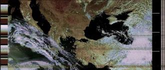
Google continues to improve its brainchild in the form of visualization of our planet, improving the quality and detail of surfaces. More recently, the company has improved its services using the new Landsat 8 satellite, which can photograph the surface of the planet Earth with a resolution of 15/30/100 meters per elementary point. The real-time satellite imagery database was only updated in 2013 before. At that time, the application used images taken by the Landsat 7 satellite, which is also known for introducing some bugs and crashes into the maps. To compare the quality of images taken by different satellites, pay attention to the screen below.

Images taken by different satellites
In the examples on the screen, you can see that the image of the new satellite shows not only improved detail of terrestrial objects, but also more natural colors. Google representatives announced that about 700 trillion pixels of graphic data have been spent on collecting a new generation of mosaics of the earth's surface. Almost 43 thousand of the most powerful computers in the Google cloud worked for a week on gluing pictures.
How to use Google Maps online
You can use Google Maps online in high quality anywhere in the world using your tablet, mobile phone or computer. Just follow the link https://google.com/maps/ or use the built-in map below and you can find the country, city and even the way to the museum by specifying the desired search parameters. And for mobile devices, you can download a special application that is more convenient to use.
To find your way to a laundromat or cafe that you often visit - just enter the addresses in the program line and you will no longer need to enter this data every time. At the same time, you can not only view the paved road to the institution, but also get acquainted with the information that relates to this institution, for example, opening hours, contact details, etc.
Let's use an example to use a map from Google from satellite 2018.
- Go to the website or open the app on your mobile device.
- You just need to point with the cursor or touch on the touch screen, and you can view the details of this area.
- In order to find out the distance between cities, right-click on one of them and select "Measure distance" from the drop-down menu. Now the second point can be specified with the left mouse button. If necessary, the point can be dragged with the mouse to another location, the distance information will be updated.
- To select the mode "Relief", "Bike paths", "Traffic jams" - select the menu sign (three bars) and press the desired option. If you are using Apple devices, click on the diamond icon with the layer and also on the desired option.
- To take advantage of high quality 3D images, click on the square in the lower left corner. It will say "Satellite", if you need to return to map mode, press it again.
- To select the Street View mode, drag the yellow man to the desired area of the map, or simply enter the exact location in the query bar, preferably with a home address.
- High-resolution Google Maps allows you to view streets in historical mode, i.e. how they have changed over time. To do this, throw the little man on the right place on the map. Select the clock icon and move the time slider to select the desired date.
Surprising Facts About Google Maps

Features and benefits of online maps in real time
From the first days of Google Maps have become a discovery for all users. They made it possible to look at the cards in a new way, to pay attention to this instrument in a new way. Everyone who accessed the Internet back in 2005 sought to immediately use online maps and see their city or country from a satellite.
It seems unthinkable, but today it is possible to view other planets of the solar system in the Google Maps application!

Planets in Google Maps
To do this, go to the web version of the program and move the image of the Earth to the maximum with the mouse wheel. Other planets will appear on the left in the block, which you can select to view. There are all the planets of the solar system and a few more of their satellites. For example, Callisto is a moon of Jupiter. True, the pictures do not allow us to view other planets as closely and in detail as it happens with the Earth.
Google maps from satellite in 2018 will allow you to view the surface of the earth and settlements in excellent quality, which cannot be done using a regular map. When compiling paper and other versions of maps, natural colors, clear contours of the banks of rivers, lakes, coloring of land areas and other color schemes are omitted, which is why we have poor orientation. Looking at the desert area on a regular map, one can only guess what kind of vegetation or terrain is there. Turning to Google Maps in real time, you can even see the color and shape of the fence at any address on another continent.
In contact with
Satellite map of Russia - high resolution images taken from space by orbital stations. The image that the user sees is made up of many individual shots. The high quality of the equipment used at the orbital stations made it possible to achieve the highest quality of shooting. As a result, on the screens of mobile devices, PC monitors, high-precision high-resolution images are available to us, the image on which is very accurate and clear.
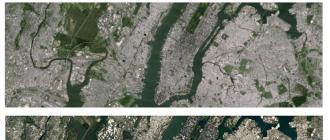
Satellite map of Russia in real time displays high-resolution images. You can see almost all Russian cities on them. By zooming in and out of objects, moving the cursor over individual sections of the map, it will be possible to examine streets, buildings, individual structures and squares. The larger the size of the city, the more detailed the section of the satellite map will be for it.
Satellite map online in real time 2016 - exploring the country together
High resolution satellite maps online 2016 - a collection of high-precision images through which you can study settlements of different sizes at a specific point in time. The user, choosing the object and scale he needs, gets his picture at the same time. By choosing the appropriate parameters, instead of the "satellite view" mode, you can display an image:
- landscape view;
- a schematic representation of Russia, its individual cities;
- satellite view - real image.
High-resolution satellite maps online 2015-2016 are the most user-friendly models of interactive map images from the website service. They will allow you to travel across the territory of the entire state, from anywhere in the world. Satellites make it possible to track up-to-date data on the location and condition of certain muddy objects from different settlements of vast Russia.
Now satellite map will be displayed more clearly and legibly. Satellite images have been updated and improved. Higher quality obtained with the help of a NASA satellite, which received an upgrade. Landstat 8 was launched in 2013 and already at the beginning of August of this year transmitted completely new, better images.
The updated satellite takes photos of the Earth with more detail, and the images are taken at an increased frequency. This means that Google has twice as many satellite images of the Earth, allowing the company to select the best and generate updated, clearer and more legible maps online. This allows users to see landscapes in more detail and be aware of the changes taking place on the Earth's surface.
Factors allow users to see more detail in landscapes and also help them be more aware of the changes that are taking place. Previously, a similar, but more outdated Landstat 7 satellite was used. Due to the end of the life of some parts, the device distorted some elements in the photo, making them more blurry and fuzzy. Diagonal stripes appeared on some regions displayed on satellite maps.
High quality satellite map
Today, images of the Earth in the highest quality are used by scientists and physicians. Absolutely any users can also look around. Here at this link http://voweb.net/blog/maps_sputnikovaja_karta_mir_online_planeta_world_satellite_map/2008-07-20-142 a detailed online satellite map has been posted, allowing you to personally assess the planet from a height of several tens of thousands of kilometers. Now everyone can open a map from the Google satellite service and, by moving it, see online the location of the object of interest to him. This can be both a continent and a country, as well as more detailed information: the location of cities, reservoirs, mountains, forests and other places.
 The possibilities of a satellite map of the Earth do not stop there. At the moment, it is possible to use it as a paper map familiar to everyone. To do this, you should go to the site, open the map from any gadget, enter data about the object you are looking for and view its location. The satellite map is so detailed that it displays the route to the selected point, as well as the location of other structures with their names. The service allows you to create a route in three ways: on foot, by transport and by car. Also, with the help of panoramic shots, you can “walk” around any city on Earth, examining the surroundings.
Satellite world map online: free use anywhere in the world
Satellite world map - a unique service. It is accessible from any place where there is an opportunity to connect to the Internet. The service is completely free and intuitive. To use it, you just need to use the buttons on the touchpad laptop or a computer mouse. You can also move pictures using your fingers on the touch screen.
A satellite map of the Earth allows you to get acquainted with the planet, view its structure, the location of previously unknown places and those objects that cannot be visited by an ordinary person. And all this is provided free of charge for any user.
Remember the movie "Men in Black", where Agent Kay looked through the orbital camera at his beloved watering flowers in the yard? The opportunity to see what our Earth looks like from a satellite in real time attracts people from all over the world. Today we will tell - and show you! - the best fruits of modern Earth observation technologies.
Attention! If you see a dark screen, it means the cameras are in shadow. Screen saver or gray screen - no signal.
Usually we get only static satellite maps, frozen in time - the details are not updated for years, and the eternal summer day reigns on the street. Isn't it interesting to see how beautiful the Earth is from satellite online in winter or at night? In addition, the quality of images in some regions of Russia and the CIS leaves much to be desired. But now all this is being solved in one fell swoop - thanks to, Earth online from a satellite in real time is no longer a fantasy. Right on this page, you can join the thousands of people who are now watching the planet.
At an altitude of 400 kilometers above the planet, where the station is permanently located, NASA installed, developed by private companies. The cosmonauts themselves or on the commands of the Mission Control Center direct the cameras from which the data is being transmitted. Thanks to manual control, we can see how the Earth looks like from a satellite online from all sides - its atmosphere, mountains, cities and oceans. And the mobility of the station allows you to consider half of the globe in an hour.
How is the broadcast going?
Due to the fact that the cameras are located at the International Station, even insignificant details are noticeable to us, which are commented on by scientists, astronauts and professional journalists. However, our Earth is visible online from a satellite in real time thanks to the work of a whole complex of people and machines - in addition to the already mentioned astronauts and the Control Center, satellite communications transmission technologies, solar power batteries and technical specialists involved in translating and decoding data are involved in the process. Accordingly, the broadcast has its own nuances - knowing them will help you see more and better understand what is happening on the screen.
Our point of observation, the orbital station, moves at an enormous speed - almost 28 thousand kilometers per hour, and circles the Earth in 90-92 minutes. Half of that time, 45 minutes, the station hangs on the night side. And although on approach the solar panels of the cameras can be powered by the light of sunset, in the depths the electricity disappears - therefore it is not always available from the satellite. At such times, the broadcast screen turns gray; it is worth waiting a bit, and you will meet the dawn together with the astronauts.
In order to find the best time for observations, our special satellite map of the Earth will come in handy - it shows not only the time of passage of the space station, but also its exact position. So you can find out when to see your city from a space height, or find a station in the sky with binoculars or a telescope!
We have already mentioned that astronauts and ground control can change the pointing of cameras - they perform not only an entertaining, but also a scientific function. At such moments, the planet Earth is not available from the satellite in real time - a black or blue screensaver appears on the screen, or already captured moments are repeated. If there are no interruptions in satellite communications, the station is located on the day side of the planet, and the background has suddenly changed, then the cameras are filming areas that are inaccessible to the public in connection with international treaties. Secret objects and forbidden territories are also closed on static maps, skillfully hidden by photo editors or simply erased. It remains only to wait for the moment when the situation in the world will relax, and there will be no secrets from ordinary citizens.
Hidden Features
But do not be upset if the camera does not function right now! When the planet Earth online from a satellite cannot be shown, astronauts and NASA find other entertainment for viewers. You will see life inside the International Space Station, astronauts in zero gravity, who talk about their work and what kind of satellite view of the Earth will be shown next. They even allow you to look into the impressively large Mission Control Center. The only negative is that even the speech of Russian cosmonauts is translated into English so that it is understood by the American employees who manage the Center. It is currently not possible to turn off translation. Also, do not be surprised by the silence - comments are not always appropriate, and there is no permanent soundtrack yet.
For those who predict the route of cameras using the possibilities that a real-time satellite map of the Earth gives, we have a tip - check the date and time settings on your computer. The server that updates the map uses the given International Station motion formula and your IP address timezone to predict the position of the orbital cameras. An online map judges how the Earth looks from a satellite solely by the time of the device. If your clock is behind or ahead of the time zone, the station will move east or west respectively. The use of proxy servers and anonymizers will also affect the result.
You are a member of the scientific program
Surely you have noticed that the quality of the picture of the planet Earth from space, live broadcast from the satellite, often changes - the image is covered with squares or lags behind the sound track. In most cases, it is enough to check the speed of your Internet connection, disable other video and file download programs, or click on the HD button in the broadcast window. However, if there are interruptions, it is worth remembering that the planet is visible live only thanks to a large-scale scientific experiment.
Yes, yes - the video on this page is transmitted for a reason. The cameras installed on the International Space Station are part of the High Definition Earth Viewing program, which is still being improved and developed. Cameras installed by cosmonauts in conditions isolated from cold and dust, but they are exposed to hard radiation from outside. Scientists are experimenting with the difficulties of seamless data transmission in space, ensuring that a map of the Earth from a satellite in good quality exists not only motionless, but also alive, dynamic. The results will help improve existing channels and create new ones - even in Mars orbit for the foreseeable future.
So stay in touch - new things appear in the world of space every day!